

Schlapperklange
-
Posts
32 -
Joined
-
Last visited
Content Type
Profiles
Forums
Downloads
Posts posted by Schlapperklange
-
-
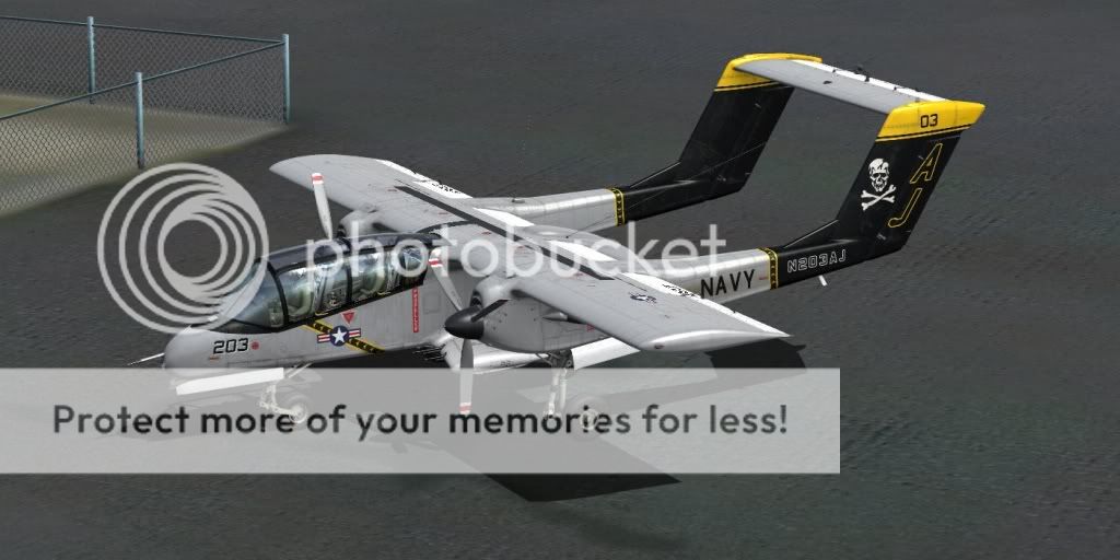
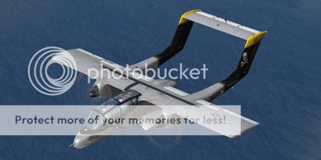
Some other previews. I gave it a civil registration - N203AJ

-
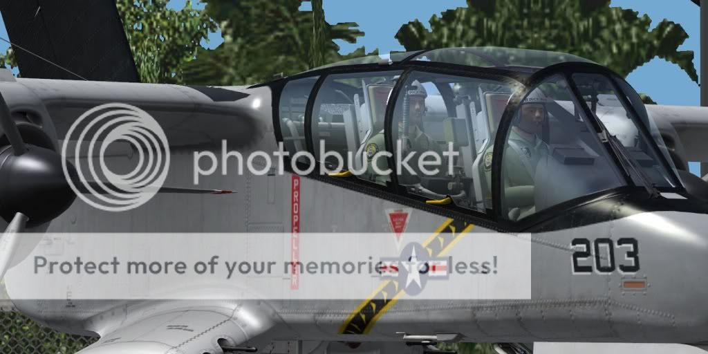
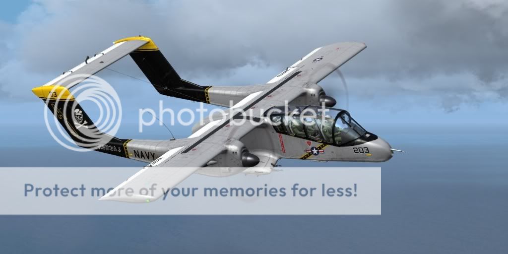
My first try to paint the Bronco. It's fictious, just an idea:


-
 1
1
-
-
Another minor niggle:
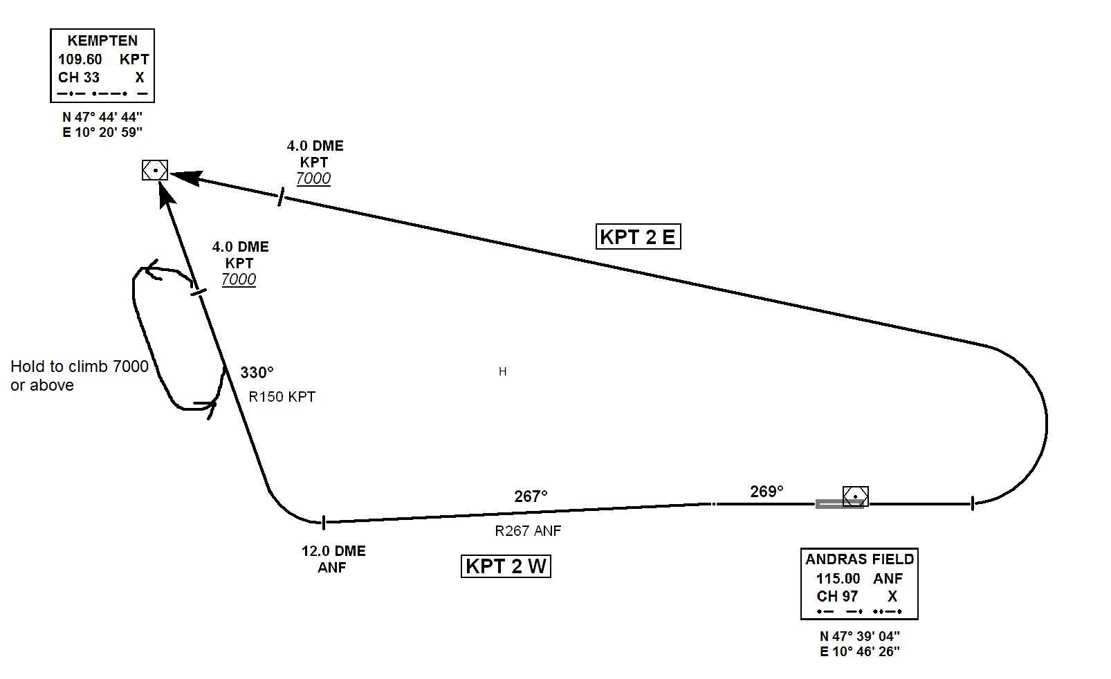
Spelling the SID's I think KEMPTEN2W and KEMPTEN2E have changed their positon.
I suppose 2W is the departure westbound and 2E eastbound, as we can see at the graphic.
But at the description of the SID's the names are on the wrong position.
2W should have a RT to KPT and 2E LT.
Very nice job
Thanx for the hint. I accidently swapped the SID names.

That happens if you don't have time to review your work.

-
I will fix the errors in the next release.
1. I will correct the spelling error
2. I will add a minimum initial climb on the KPT 2 W SID of 1000 ft/min until 3.0 DME ANF to keep clear of the hill.
3. The R097 KPT on the KPT 2 E should be changed to R096 to minimize possibility of overshooting. It works well if you keep strictly the speed limit, but with strong wind from south you may overshoot easily.
4. I am thinking about adding a SID via INN NDB. Something simple like: On RWY track after 11.0 DME ANF RT direct INN NDB.
Did someone else experience problems with the ANF VOR tuning?
There is a DME at EDDM which also uses 115.00 Mhz. Maybe the Andras Field developers should change the frequency in the next release to eliminate possible interferences.
-
Here is a new set of charts.
Now added the SID chart and formatted them all into A4 PDF files correctly.
I hope you enjoy!
-
2
-
-
I personally don't see the problem with departing aircraft, rather the opposite. Take your original post along with distances. I've flown this umpteen times.
Departing aircraft from Rwy 27 and going by the calculated distances (again from the original post), can reach over 5000ft before hitting KPT, by my reckoning you should be able to hit a minimum 7000ft. On a Rwy 09 departure you could make it either the same or at 9000ft. Either way I see the TA being 5000ft.
Of course it is possible to fly the SID Rwy 27 with an arrival AT 7000 ot above - if your aircraft has enough climb capability. For most it should be no problem. Maybe we should just assume that this SID is no problem.
SID Rwy 09 is no problem at all.
For the STAR this would be another matter. Having to arrive at KPT AT 5000ft you would therefore have to HOLD at whatever altitude you were at (say 15000) down to 5000. My point being, it would depend on Departure traffic as to what hight Arrivals would have to extend the hold and more importantly, at what altitude.
Arrivals should be already AT 5000 when passing/holding at KPT VOR (if not other directed by ATC). Maybe I should fortify that in the remarks in the STAR chart.
I may well be incorrect in my assumptions but, I'll opt to stand being corrected if wrong. This assumption being that we only use KPT for Arrival/Departures. There are other options open but would require the waypoints to be made/added to various programmes.
I intentionally don't want to use other navaids. Andras is a small airfield. So we should keep IFR proceedures short. And an insertion of custom waypoints brings new problems. Just look at the problem how to add Andras Field to the AIRAC databases.
-
I know for some ILS approaches, the FAF is simply glide slope interception, where ever that happens to take place. It looks like for RWY 27, that happens at 6.6 DME and is also already listed at the FAF so that works perfectly fine.
My question is: Must there be a Maltese cross at the FAF on the chart or not? Most airports' FAF have a RNAV fix with coordinates and a name.
As far as the SID, I know some airports in California have a similar problem. What they do to overcome it is they would put a hold in somewhere in the procedure where it is safe enough to enter at a lower altitude. In this case, there could be a hold at KPT that would be used only if an aircraft could not attain 7000 by the time they reach it. They enter the hold at whatever altitude they had managed to climb to at that point, then continued the climb in the hold. Once they were at 7000, they exit and continue on their way.
The problem is, that departing aircraft must arrive at ANF VOR higher than 5000 ft to not get into conflict with arriving traffic that arrive at 5000 ft. So a hold at ANF doen't solve the problem.
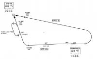
If we have to add a hold for climbing, it must be before ANF, for example like this:
-
Thanks for bumping this. Maybe it should be pinned at the top as it has very very useful charts!
I do have one question about the ILS Charts though. Since these are formatted for Europe, I don't know if maybe there is a difference between FAA Charts but the Maltese cross is usually the Final Approach Fix in the Profile View. Its over the NDB on both Approach Charts here. Also just a note, the Decision Height for ILS27 is too high (over 250 feet). These are the heights normally found on a Non-Precision Approach.
Once again, I'm a US Pilot so I don't know if things are different in Europe.
Well, the charts are still in beta. You are right about the FAF, but actually there is no real FIX. So I am not sure if I should add a cross to the chart or not. For first I decided not to. I should delete the crosses over the ANF NDB also. It would be great if Aerosoft would create two real Approach Fixes in future releases and give it a name.
And yes, the Decision Heights are quite high. For ILS 09 this was fully intended, because there is a small hill on approach, that could get dangerous if too low on approach. For ILS 27 I just copied the heights. If you can give me some better, more realistic values, I will change it.
Here is an Idea about the SIDs:
I don't want collide with other procedures of other airports around Andras Field, so I keep it close to the airfield. And there is only KPT VOR in vicinity.
But the problem is, that KPT VOR is very close when flying the SID for RWY 27: You need tough climb rates to be at or above 7000 ft before KPT VOR.
7000 ft because if you go lower, you will have a conflict with arriving traffic.
Still missing some numbers. I have only few time to do some test flights.
-
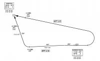
Here is an overworked STAR - now there should be no conflict between Aircraft on ILS RWY 27 approach and those on KOGOL arrival.
-
Ok, I am back.
Any Ideas about the SID routings?
-
For RWY09 all Approaches are perfect, also BODAN1P for RWY27. But MERSI1K and KOGOL1T for RWY 27 via KPT VOR is somehow cumbersome.
Why not directly from KOGOL to EASF and from MERSI via AMGAS direct. I'm thinking of a STAR i used today when flying from Andras to Trondheim.
See attached file.
Your idea is good and I know it seems a little unorthodox to make a detour for an approach on rwy 27 via KPT. But most customers of Andras Field will fly with small aircraft of which many may not be able to fly RNAV or GPS approaches. My idea was to fly the ILS approach by radio navigation only. So all ILS/VOR-DME equipped aircraft can use it. The STAR was made additionally for those who navigate with FMC/GPS until reaching IAF (KPT). In my opinion this is suffient for a small airfield like Andras.
And there is another reason: The fixes you suggested to use are enroute intersections. I am not sure if it is usual to use them as approach fixes. Trondheim has it's own approach related fixes.
If there would be a better positioned VOR (like the former EUR VOR) I would be happy. But I want stick to the active NAV points. This is important if we want use Andras Field on networks like IVAO or VATSIM one time (I hope so).
-
-
Is it possible to make a offset approach for rwy 09? That would be the safest one due to the montain
Here is an exemple
http://www.ippc.no/n...ENKB_5-4_en.pdf
I can't open this link.
-
Great work again!
Have you any idea about an approach for incoming from north/northeast and south/southeast, eg. via MAH or EUR VOR?
I can't find EUR VOR, but I wouldn't use MAH VOR for an approach. There would be a conflict: MAH is used for EDDM ILS 08R approach, besides it is quite far away.
I am thinking about a STAR via MERSI, KOGOL and BODAN that all end at KPT VOR. If you fly only VOR to VOR, I recommend also you start approach at KPT VOR.
This would change if we would have another usable VOR in close east of EAFS, but there is not.
-
Please keep in mind these are not final releases!
-
-
2
-
-
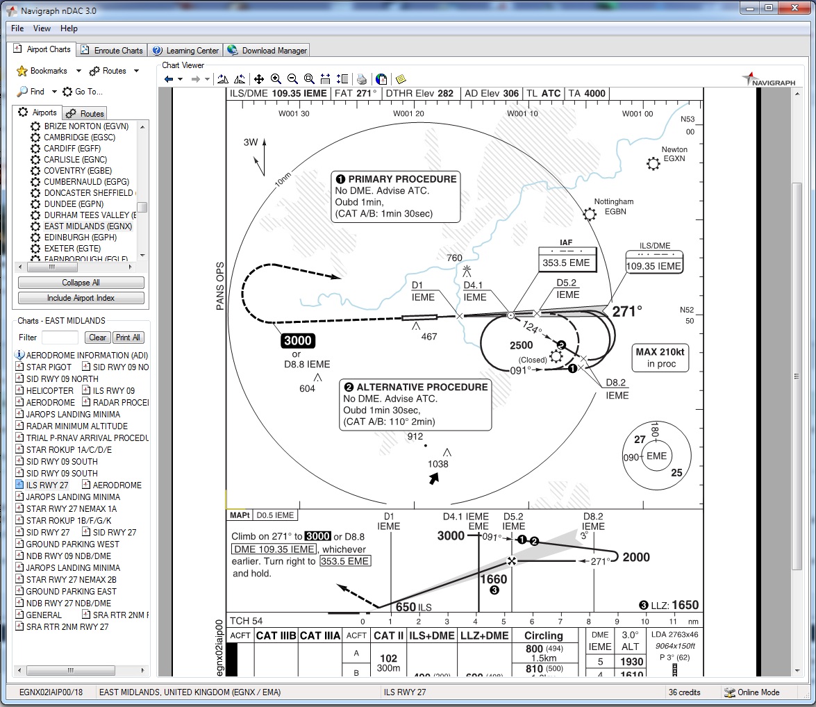
We are obviously talking cross porposes here as what I see and read is different to what you see/read in relation to the type of chart it is. I see it as an ILS/DME which acording to the airport diagram is on a frequency of 109.55 (AFK) for Rwy 09. You are using the VOR on 115.0 (ANF) which is a VOR. The chart states at the Top Right Corner it is an ILS CAT I and unless I'm totally wrong or missing something then please take a look at the attached Navigraph chart for East Midlands EGNX.
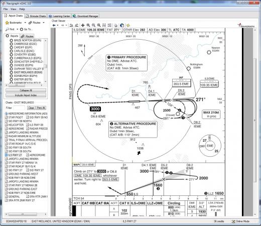
I apologies in advance if I am wrong or missinterpreting the type of chart you are producing.
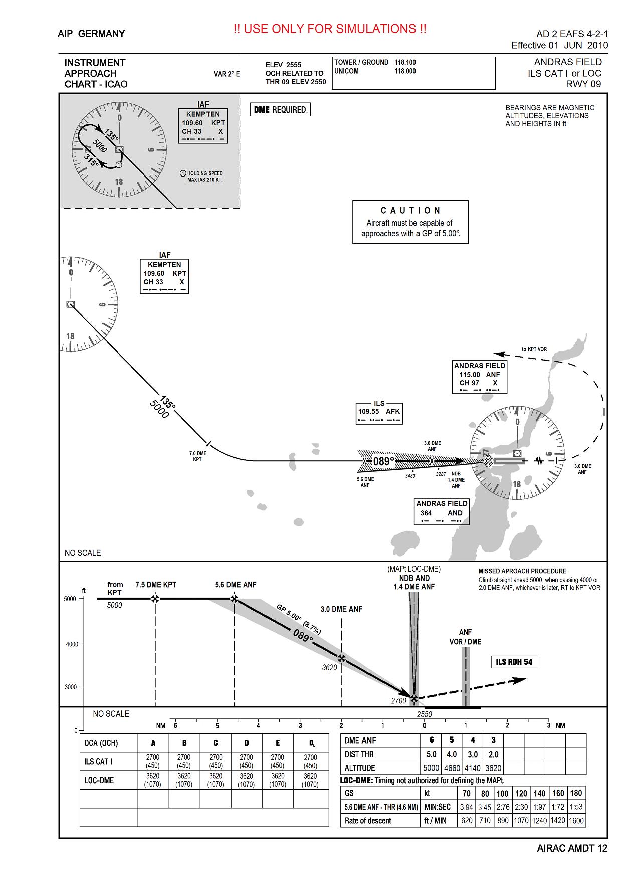
Ok, I give you an example, here for Frankfurt (EDDF) ILS CAT II & III or LOC for RWY 07R:
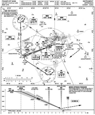
You can see here that the approches begin related to RID or TAU VOR until turning to intercept the ILS. Then DME is related to FRD, which is just a DME, nor an ILS neither a VOR.
I did it in a similar way in my chart. Maybe in UK it is different. But the reason why I refer to a german DFS chart is clear: Andras Field lies in german airspace.
If you have difficulties to fly the approach try to do it as followed:
Use NAV 1 to fly on 135° radial from KPT and tune ANF on NAV 2. At 7.0 DME KPT turn left HDG 115, tune AFK on NAV 1 and intercept the ILS. Switch DME to read NAV 2. Intercept G/S at 5.6 DME ANF.
-
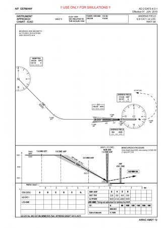
Just picked up on another minor error after a test flight. On the chart you leave KPT heading 135 till 7DME KPT then all other references to the ILS is on the ANF VOR!! Shouldn't the references refering to ANF be amended to read APK and all distance (DME's) refer to APK?
I say this as this is how the Navigraph charts are. Also, trying to fly the glide slope for APK on the ANF VOR is blasted hard!! Just an observation but thought I would point it out.
I don't know the Navigraph charts. I also don't know APK. I think you mean AFK, the ILS.
Take a look the the DFS charts and you will find out, that all DME related numbers are never related to an "ILS-DME". If the ILS is not working, you need another DME for your approach. This may be a VOR-DME or a stand-alone DME.
If you saw something different, please tell me for what airport so I can check it out.
But there is an error in the profile: I forgot to change the 7.5 DME KPT to 7.0 DME KPT. It will be corrected in the final release, in which I will add a chart for ILS RWY 27 and maybe STAR and SID charts - but after my vacation ... expect 5 weeks minimum

-
Just one error I see on the chart is the missed approach information. You state a RT when in fact it should read LT. Just a minor issue but well done.
Thanks, got it.
Here is the final release candidate:
Alex
-
2
-
-
Here is a pic that shows the the position (calculated 6.8 DME ANF) on that you would intercept G/S on a 4.0° approach.
It seems possible, but over the hill you might come below OCA of 444 ft. And LOC-DME should be prohibited!
I my opinion it is too dangerous.

-
Hi,
With regards the minima for the approach with the lighting we have at Andras we can only really consider it a CatI approach. So we'd be looking at a DH of not less than 200ft. The problem is this only applies for glideslopes up to 4 deg. I've just had a look at London City's 09 app (another 5.5 deg slope) suggests the following:
CAT A B C
OCH (384) (414) (444)
With this in Mind I'd suggest a minimum RVR 0f 1200M with the available lighting.
Your chart is way better than my scribbled attempts. Well done!!
I didn't see your post. I entered an OCA of 450 for all classes. But I will adopt your suggestions and change the chart - it seems to be more realistic. Also I delete classes D and E. They shouldn't operate from Andras Field at all.
-
Alex,
that's what I got from Andras:
Regarding OCH I think: Das musst Du Dir aus den Fingern saugen"

And as I remember the DH depends on type of aircraft/airline procedures/pilots
Ok, that's what happened

Alex

-
Great Work!
I was thinking about the same thing some weeks ago, but only realised in a first step the necessary changes for some navigraph files to see Andras Field in my Mustang.
Do you still need the data for the NDB and VOR?
Yes, the coordinates would be nice to know.
And I need some help on the OCA (OCH) and Timing entries.
Alex
-
New update:
The chart should be useble now. Maybe someone can do some test-flights and report experience and report errors or make suggestions for improvements?
-
1
-


Civil Air Patrol WIP
in OV10 Bronco
Posted
Very nice!!!