


Jethro7
-
Posts
7 -
Joined
-
Last visited
Content Type
Profiles
Forums
Downloads
Posts posted by Jethro7
-
-
Hi Jethro,
as Otto had already written, this map is a compromise between speed of image rebuild and the extreme cost of a detailed map.
But if you feel like you then you can make your own land surface.
Open this file ..\Database\UserObj.TXT and please read the instructions at the beginning of the file.
Regards,
Volker
Hello Volker,
I thankyou for your input, sounds very possible, im not after "mm" accuracy, but the idea that the map could be corrected slightly is very appealing.
I have had a read through the (\Database\UserObj.TXT) It would seem that if the Lon/Lat position can be determined on the (fp) in the DB where the iregularity is located then by giving it new co-ordinates it may be drawn to encompas the airport proper, without adding to the database any new polys. The line structure would be elasticised to the new location keeping the same attributes of colour and type and the poly would be filled at its new location.
Does this sound correct to you,
The only question is, which actual (database file) am I going to edit, and will I need to decompile it before hand and recompile later, are there any tools I will need to do this.
Kind Regards, Jethro.
-
Jethro, what you see is correct and happens very often in FSC: Reason is that the accuracy of the coastlines is extremely low. And if an airport is very close to the sea, it happens that parts of it are placed in the water.
But IMHO this is just a comestic problem, as FSC is mainly intended for IFR and not VFR flights. And therefore this inaccuracy has no negative impact.
And there is no solution (like more detailed maps).
A solution could be if FSC would use e.g. GoogleEarth maps instead of its own. But this has an significant impact on performance because you have to use a lot of layers to show all the things you can see in FSC.
Another option would have been to use profeesional maps, but they are extremly expensive for commercial use and would raise the price so that no one would buy it.
Hi Otto,
I thankyou also for your advice, very welcome perspective on the issue, although it does seem a little strange that an Airport located on a tiny Island elseware in the Pacific for instance, can be positioned entirely on the land mass in the right geographic location, but not an International Airport located further from the water and attached to a massive Island called Australia.
Attention to a small detail, I wouldn't mind so much if it were only a little known airport but it happens to be one of Australias main travel centers. I do understand how making the map too detailed could be a problem keeping up the FPS when connected to FSX and google maps would overcomplicate the issue, but what about the intergration of FSMAP as a better moving map inside FSC9 it has some benifits with some feature rich and topographical information as well.
Kind Regards, Jethro.
-
Hello Jethro,
Please place your aircraft in the sky over the area that looks like its in the water then save the flight. Now disable your 3rd party scenery and then load the saved flight up, are you then over water.
This should check to see if the scenery has added any land to the default scenery.
Hi Shaun,
I'm back and its only 4:05am here, I have been busy testing and taking pictures, so here they are 6 shots in all, the first series of three are Orbx enabled, with and without the FSC9 GPS connected, you will be able to tell.
And the second series of screenies are from the exact same location Default FSX no ORBX YBBN scenery or ORBX FTX Australia.
The most revealing thing here is that the land area is nearly identical in coverage. But the Default FSX is of such poor quality that ORBX is an absolute must have, Microsoft really let Australia down when it comes to default scenery and terrain. The FSC9 Map also shows the Runway 14/32 in the water also for Default FSX.
looking forward to your response, thanks for assisting with this issue.
Kind Regards, Jethro.
Pictures Below
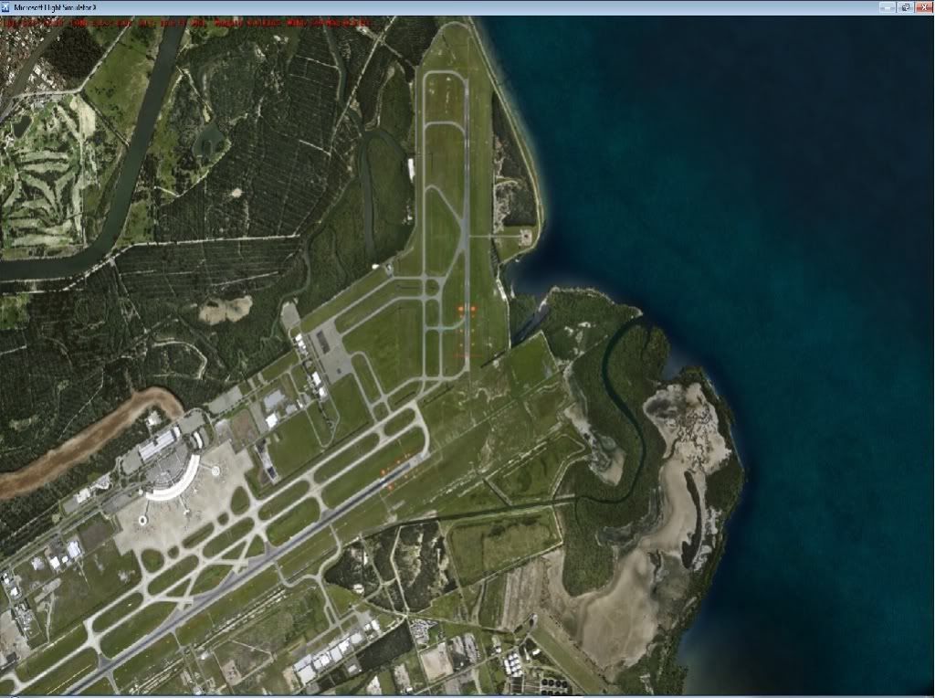
ORBX Enabled YBBN
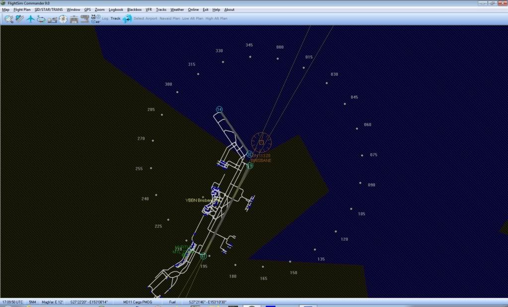
ORBX Enabled YBBN FSC9 GPS Not connected
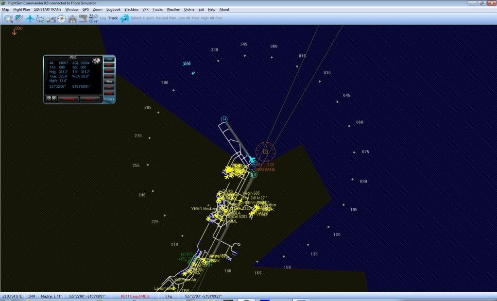
ORBX Enabled YBBN FSC9 GPS Connected
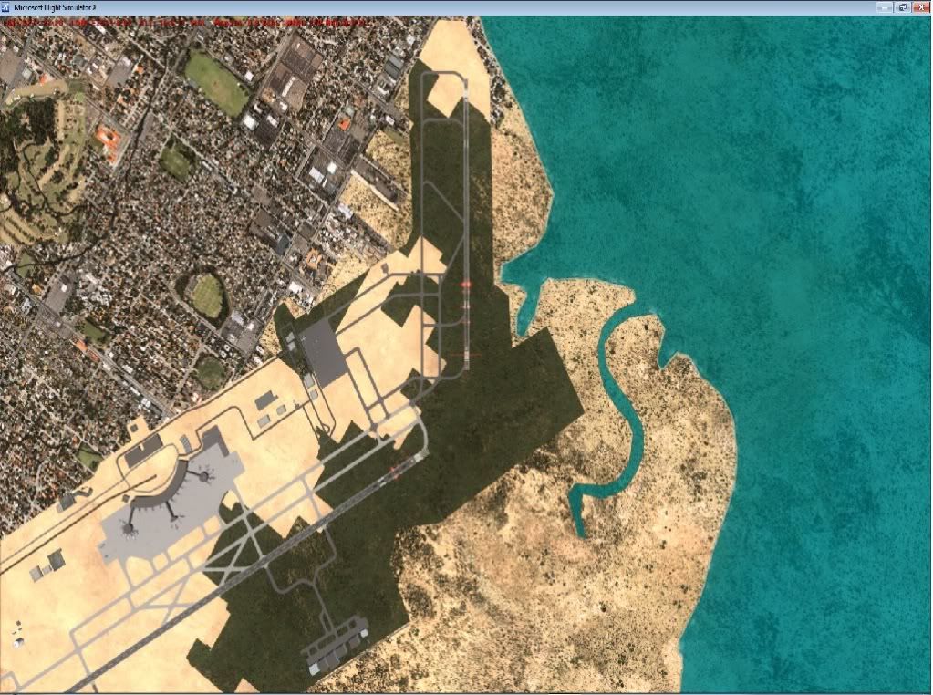
FSX Default Scenery Identical location at YBBN
FSX Default FSC9 GPS not Connected
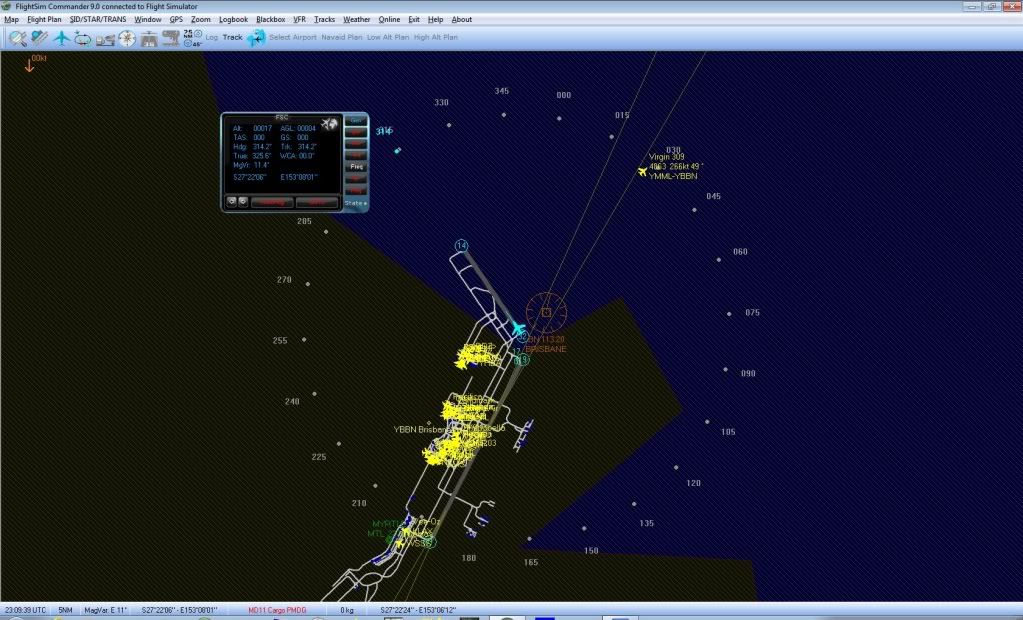
FSX Default FSC9 GPS connected
-
Hello Jethro,
Please place your aircraft in the sky over the area that looks like its in the water then save the flight. Now disable your 3rd party scenery and then load the saved flight up, are you then over water.
This should check to see if the scenery has added any land to the default scenery.
Hi Shaun,
Thankyou for your reply,
I will do as you ask, the runway in question is normally located on dry land in the same geographic location with default FSX scenery. My initial screenshot was with ORBX YBBN Brisbane scenery and of course FTX AU Australia SP4 scenery, I will set it back to FSX Default and re-run FSC9 for YBBN airport and see what happens, then I'll report back with screen shots of FSX default location and FSC9 map with FSX scenery default, and also an Orbx FSX scenery screen shots.
Kind regards, Jethro.
-
Hello Aerosoft support crew
This will be my very first post on the Aerosoft Forums, a two part question.
1) FSC7 made redundant (dissapointing purchase)
2) FSC9 New purchase Mapping issues.
I have recently purchased the Brilliant FSC9 program for flight planning and tracking, to replace my dissapointing FSC7 which I was not able to use for very long before it was made useless by the withdrawal of DAFIF after the 911 incident, it would have been appropriate for Aerosoft at that time to recall the software and replace it with a fully supported version once the database arrangements had been resolved, but alas no offer was made and I can't help feeling a little regret, maybe an offer for another software title could be made in light of this, I paid around $100.00 back in 2006, and emailed Aerosoft at the time the response was not very encouraging, (more or less "bad luck"). But I am not beyond giving Aerosoft another go so I bought FSC9 for FS2004 & FSX.
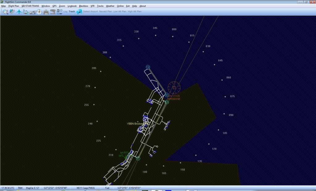
The 2nd part relates to FSC9 and the airport at YBBN Brisbane Australia, on the moving map Most of the airport is located on the Marked land area, but Runway 14/32 at the northern end is completely in the water (jpeg below). Is this a general inaccuracy at airports located close to water that can be corrected with an update or fix/patch, are there more accurate land maps for FSC9.
Your feedback would be greatly appreciated.
Cheers Jethro
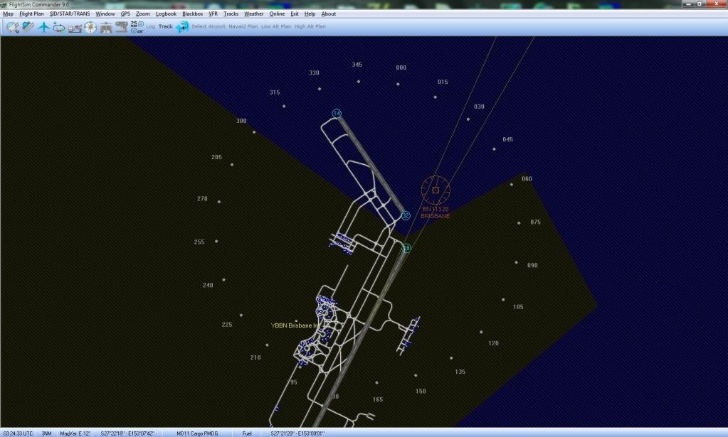
FSC9 inaccurate map at YBBN Airport
in Tools/Missions General
Posted
Hi Otto,
Thanks for responding, what you and Volker have said so far makes a great deal of sense, and I will take your advice with much appreciation. You have mentioned moving map programs specifically for VFR flying which I have also investigated. Currently I use the free FSMMap for VFR, someone over at orbx has produced maps for this program covering the entire continent of Australia which seem to work rather well on my Dual monitor setup, they have incorporated all the airports that come with ORBX and many OZx and FSX airports as well, but not much good for plotting a course or flight planning or even having the abilities of the FSC9 GPS when it comes to locking and loading NAV directly while in flight, this feature I really love about FSC.
So thankyou all, I will continue Just flying and use FSC9 the way it is, I really don't want to work that hard for a small benefit, FSC has many more useful facilities that will I'm sure will out weigh the small negative aspect with map detail.
Kind Regards, Jethro.