


Urs Wildermuth
-
Posts
20 -
Joined
-
Last visited
Content Type
Profiles
Forums
Downloads
Posts posted by Urs Wildermuth
-
-
Great photos Urs

The lake certainly looks a lot smaller
Hi Matt,
it is certainly a lot lower than usual, I overflew it last year from a distance and all that brown area was under water then.
I hope to get it later this year again. In any event, I was able to identify the place from a distance, the hills and other landscape are spot on.
Best regards
Urs
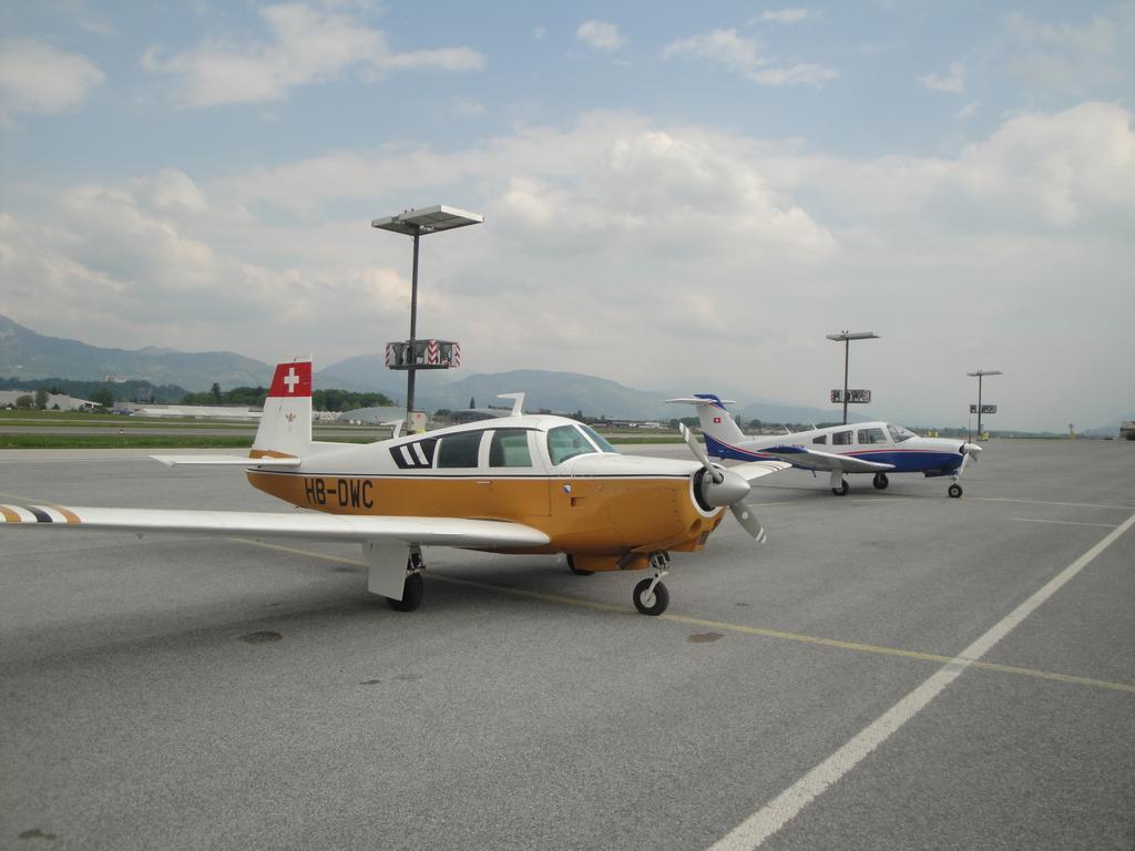
HB-DWC
-
In the real world...
The lake is very dry at this stage, yet I did overfly the area of Andras Field today.
The area is well reckognizable, especcially the hills on final from the west.
Or maybe they have just started building the real thing and nobody told us
Anyway, here's the bird from which this pic was taken from, a few hours before in Salzburg.
Best regards
Urs
-
Theres also 1.15...whitch is a full installer too,and the latest update to andres field.
Jup, just found out. All settled on my part, now I only have to remember to check the sales section more regularly to finally get my own plot.
-
Hi Urs,
1.11 is a whole new installer available from your order page
Simpily uninstall your existing AF and repace with the newly downloaded 1.11Right, thanks. Will do that.
Best regards
Urs
-
Hi guys,
somehow I totally missed to update since Version 1.06 and went about to find the updates since then. However, I can only find 1.11 and larger. So how do I get my 1.06 up to 1.10?
Thanks a lot.
Best regards
Urs
-
Hi Urs,
Why don't you add 1.04?

No customs at AF, I personally declared it as being a duty-free zone...
If people argue that, I may fight for our independence. A kingdom maybe or just as a simple Principality as your friends quite close to Zurich??
BTW, next time you fly above the place consider taking some nice aerial photos, wouldn't take much effort, maybe just a big hole on the bottom of your bird:D
Andras
Andras, good question, I downloaded what was in my order history (update) as I have to complete the FXP Test today. So where do I get 1.04?
Edit, found it. the file seems to have no extension, so I found I have to rename it to zip. Ok, where are them wabbits?
Re customs, LOL, fine. My 313 pax of today will be happy they can just walk in. That principality you talk about btw is a member of EU and they have a heliport
Yes, if I had realized how close I was then, I would have turned south and had a closer look. I will. I reckon you might figure out where I was that day and it won't be the last time I fly there
(otherwise prolong the line ZRH- north of Andras Field until you hit a familiar location... or you can cheat and check my website (you've got mail for this.)Anyhow it is great fun and I am looking forward to see this develop.
-
See Finals.jpg for this idea.
But overall, ILS 27 is very (too) tight
Mathijs,
a few remarks.
For my tests today I flew to KPT and then a southern direction to intercept the ILS 09 (it's easterly winds today). Going out towards the West, I'd suggest a straight climb to about 5000 ft and then left turn to intercept KPT again.
As this is supposed to be a former Air Force Base, I don't see it too unlikely for it to have ILS, particularly in this area which has a lot of low cloud and fog in winter.
Kempten VOR would be the logical start of any IAP, certainly to 09 but also to 27. Eurach should not be used any more as it is withdrawn in real life and therefore won't be in many databases. FUSSE would be another but due to the Terrain I'd suggest to make it an arrival route towards KPT and then work out the rest from there.
The APP to 27 can be drawn from KPT either directly to the VOR like you suggest and with a teardrop back onto the ILS, or it could go onto a sort of downwind and then onto the ILS. From the East, I'd suggest startig at KOGOL, as it is on an airway and in the correct distance too.
For SIDs, I would do two sets, one to KPT again and the other to KOGOL. FUSSE again will require quite a bit of climb gradient so it can be a transition after KPT.
I'll try to put something together but I am a lousy draftsman, so I'll have to figure out how to draw a proper map. Where is Georges Lorsche and his "Final Approach" when one needs it
Best regards
Urs
-
Hi,
just added version 1.3 and it's all ok now. Right, now let me get that review started!
Andras,
Thanks for the kind words! It's always the best to get compliments from someone who's been associated with FS as long as you (and we) do...Actually, I have always felt that this is what you should do once, create your "own" airport as the artist you are. Remember, we even talked about something like that during the Vienna Interstate. I am glad you did it.
BTW, I overflew the site of this airfield recently without realizing yet where it was. And of course, you realize the irony, creating this place in Bavaria of all places where they are in a big hurry to close just about any airfield they can get their hands on
Exactly the right sign. 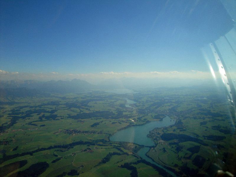
Here a pic I took pointing in that direction.
Oh yea, I hope this field has customs
(As a Swiss pilot, I have quite some problems with this now, as many German airfields have done away with customs due to Schengen.) -
Moin Urs, about the shadows I got them as well (see attached) and we'll see if this can be changed.
Hi,
I try again to upload a pic. Otherwise I'll send it per mail.
Check out the trees on the lower right, the "air" around them are not transparent.
Best regards
Urs
-
Hi Andras,
just completed an approach from the East, that is onto RWY09. I think the Glideslope is a tad flat for this one, the terrain on final comes up really close. It's fun but I think that runway may need some steeper GS to make it "real", maybe 3.5 or so, same for the VASI
Great work, superb airport. Why don't they do this in real instead of turning more and more such former airbases into shopping centers and test beds for BMW...
Keep it up my friend!
-
Hi Andras, hi Mathijs,
what a great idea and what a great product. I have been thinking for as long as I know Andras' work that this is something that should be here, and now it is.
Hey, I never forget the fun we had with many of your excellent products, which are of one kind in this flight simulation world. Great fun, if not trying to land an MD11 on a frog, or doing other crazy stuff.
The artist has shown again that scenery design is that, art!
One small question: In the vicinity of the airport I have several trees with transparency problems, meaning their black background can be seen, see attachment. How to get rid of that? I need "clean" screenshots for my review
Anyway, the best of luck to this great product. I somehow wish there were people like this in the real world too, with all those old airforce bases going to waste in Germany.
-
Hallo zusammen,
sorry, ich hab das erst jetzt gesehen. Unser normales Supportforum ist auf http://www.danur.com
wenn ich bei flight operation center flugpläne mache, werden sie nur als direct-routen im gps angezeigt. weiß jemand wie man es hinkriegt, dass auch die an und abflüge angezeigt werden? die an und abflüge hab ich im router schon dazugemacht. im foc-map werden sie auch angezeigt.was mache ich hier falsch????
Im Export Tool hast Du die Möglichkeit, SID/STAR mit anzuwählen oder nicht. Das ist wegen Addons wie PMDG, die die SID/STAR's extra haben.
Was genau meinst Du, sie werden als Direct-Routen angezeigt, also nur airport zu airport?
Beste Grüsse
Urs
-
Will it give you the EPR settings for a B727 on a hot day at 25C leaving FAJS (4500')??
That's about what I would like to use it for

Hi,
no, FOC does not provide Take Off or Landing performance. For that, you need either the corresponding Boeing Laptop Tool for the exact airplane you use, or the AOM.
Performance records include:
- Basic data
- Time/fuel/distance to climb/descend
- Cruise data
- holding data
- EROPS/ETOPS data where applicable.
All of these are weight related and include corrections for ISA deviations.
Hope this helps.
Best regards
Urs
-
I am also thinking to get FOC, another question is does FOC good at fuel planning? I am trying to fly WSSS-KEWR but always run out of fuel. I already made changes in my payload (using FSP). I guess I need another route and good fuel planning.
Hi,
what aircraft are you using? Maybe FSP is right after all :?
However, if you calculate it with FOC you will get what the real plane will require, if it runs out of fuel, it can't be done, if it doesn't, it can. This does sound like a 777 or so route, so if you let me know, I can have a look.
Best regards
Urs
-
Hallo zusammen,
Paypal ist seit heute nachmittag auf unserer Seite aktiv.
-
Hallo Carsten,
wir checken das gerade.
Wenn Du in der Zwischenzeit was brauchst, mail mich an, da können wir was tun.
-
Na so ist das halt. Die Quelldaten sind ja nicht mehr kostenlos wie sie das früher mal waren. Also kann man wohl auch nicht erwarten, dass man sie umsonst bekommt.
Da kannst du dich bei der US-Regierung bedanken, die unter dem Vorwand der Terrorbekämpfung die Sicherheitseinstufung dieser Daten geändert hat.
Das heißt wenn der böse Terrorist aktuelle Daten haben will, muss er jetzt dafür bezahlen. Na wenn das nicht eine kapitalistisch perfekte Lösung ist.
Nur muss mir mal einer erklären was es dem Bösewicht nutzen soll wenn er die aktuellen Wegpunkte im Luftraum kennt.
Die Daten die wir verwenden waren niemals kostenlos. Wir haben die von Dir verwendeten Daten von DAFIF nie verwendet, da FOC von Anfang an auf ARINC Daten basiert hat. Und die Lizenz, die wir hier bekommen haben, ist SEHR fair, wenn Du Dir mal ansiehst, was man für die im Luftverkehr einsetzbaren Daten bezahlt....
Navdata/Navigraph haben ja erst in 2006 umgestellt, als eben wie Du sagst, DAFIF wegen kommerzieller Forderungen geschlossen wurde. Sofern ich weiss, war dies übrigens nicht das US Government, die hier federführend waren sondern die Forderung kam aus Wirtschaftskreisen vertreten u.a. durch die EU. Es ging rein ums Geld, nicht um Sicherheit.
Beste Grüsse
Urs
-
@Urs: ist damit zu rechnen, dass Navigraph es in seine cycles aufnehmen wird (ich update dort die cycles jeden monat)? ein einmaliger update ist mir leider zu wenig ausserdem bleibt die gefahr differenter nav-databases.
Im Moment nicht. Die Updates (sowohl Wetter als auch Navdaten) laufen bei uns über eine recht komplexe Serverstruktur. Dazu laufen die gegenwärtigen Verträge noch recht lang und bis dahin ist mit keiner Aenderung zu rechnen.
Für Power User wie Dich, der alle 28 Tage updaten will, kostet das Abo 99 Euros pro Jahr, was bei 12 Updates 8.25 Euros pro Cycle ausmacht, das entspricht gerade unseren Kosten.
Wetter ist 10 Euros im Jahr, ebenfalls reine Serverkosten, im Connectivity Pack (Basic und Plus) ist 1 Jahr Wetter dabei bereits enthalten.
Beste Grüsse
Urs
-
Hallo zusammen,
FOC wird seit erscheinen mit dem gleichen Navdatencycle ausgeliefert, der dem Release von FS 2004 entspricht. Das ist sowohl in der Online als auch inder Boxed Version so.
Updates sind erhältlich via http://www.danur.com, ein Single Update kostet 15 Euros. Das ist die Lizenzgebür, die wir hier weiterverrechnen müssen. Die Boxed Version kann via uns auch zur normalen Online Version mit Wetterabo e.t.c erweitert werden. Dabei kostet der Connectivity Pack 19 Euros und enthält ein Jahr Wetter, oder 29 Euros dann gibts ein Jahr Wetter plus einen aktuellen Navdatencycle. (Einzelpreise: Wetterabo 10 Euros, Single Update 15 Euros).
FOC SE ist, das steht auch bei uns auf der Website, vor allem für die Kundschaft gedacht, die ein gedrucktes Manual (in Deutsch oder Englisch) sowie eine CD bevorzugt. Sie ist mit der normalen 1.27 identisch bis eben auf die Online Optionen.
@martin
wenn Du Updates haben willst, wir können das mit der Kreditkarte regeln, schreib mich mal an.
Beste Grüsse
Urs

That is what it looks like... Mk2
in Andras Field - General
Posted
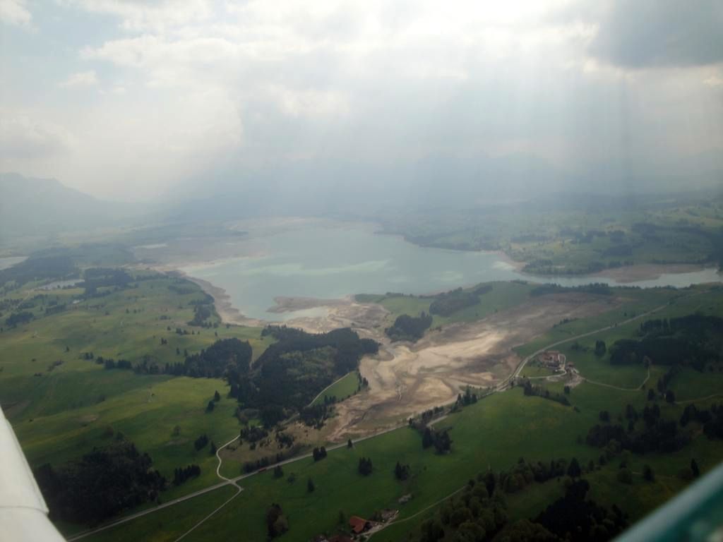
So folks, here it is again, picture taken on July 19th on the way home from Bulgaria.
I did learn in the mean time that the lake is artificial and will get emptied or significantly lowered during winter. That is what the last pics I made reflect.
That was on April 26.
The newer image was taken on the last leg on a trip from Zürich to Primorsko and back, 2000 NM altogether.
Full travel report in German for those who are interested. Aircraft was a Mooney M20C.
Best regards
Urs
http://www.hbdwc.ch