


Bulau
-
Posts
147 -
Joined
-
Last visited
Content Type
Profiles
Forums
Downloads
Posts posted by Bulau
-
-
OK, thanks, Ian. I flew another similar task last night (separate start waypoint) and the same thing happened. I noticed the "overlay" option, but haven't looked into it. I'll try the navpoint idea, it sounds like it will work. In the meantime, I went through the list of IGC analysis software at the Worldwide Soaring Turnpoint Exchange, and ended up with this short list:
CouTraCi
http://coutraci.free.fr/index-us.html
Freeware
Flight Display
http://www.soaringpi....com/FDpage.htm
Freeware
FlightMap
http://www.flightmap.demon.co.uk/
Mailorder,limited maps, 49 pounds
GPLIGC
http://freshmeat.net/projects/gpligc/
Freeware
IGCview (Ian Forster-Lewis)
MapGlider
http://gschneid.free.fr/index_us.html
Freeware
StrePla
129 EUR = C$170
See You
http://naviter.si/in...id=9&Itemid=213
129 EUR = C$170
TaskNAV
35 pounds = around US$55
There is Peter's suggestion on there, and also your own IGCView. I've download all the free and demo ones to try out and see how they work. My ultimate goal is something that can be used for multiplayer scoring from submitted IGC files, but that will handle the sort of tasks I might create.
-
In my ongoing effort to make FSX multiplayer soaring tasks more like RL soaring tasks, I've been floundering with various problems associated with the task start. Since we are, for the moment, stuck with how the FSX GPS handles waypoints, it's possible to work around some of the limitations at the IGC level. Ian's Sim Logger is the ticket for generating the IGC, since it also performs a host of FSX related checks to verify the log.
For viewing and analysis, I had been using Naviter's See You, and it is very good software for that job, however, it is very expensive, costing, I think around 170 Euros. So I've started using the Cambridge Aero Explorer, which Ian had suggested to me. It seems to do nearly all of what I need, except for this problem with specifying the start sector.
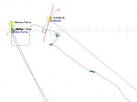
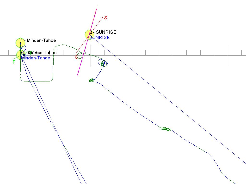
I made a task, which starts at an airport as FSX requires, with a start gate as a separate waypoint. The task is set in Minden, and the start gate is the nearby Sunrise waypoint, which is commonly used for task starts. Apart from the problems I encountered with the FSX GPS (related in a separate post), I could not figure out how to force Cambridge Aero Explorer to use Sunrise for the start of the task. It seems the IGC generated by Sim Logger had tagged the takeoff, KMEV, as the start. I could do everything else I wanted: change radius of turnpoints, define a start and finish line of certain length and orientation, everything except change the start from KMEV to Sunrise. I know that See You could do this.
So, I hacked the IGC, in Windows Notepad, and deleted the entry referencing KMEV as the start, renamed it "mod..." and it works...now Sunrise is the start, but obviously, this is not an optimal solution, but I can't find any other way. Attached screencap is the modded IGC, with the defined start and finish lines. Ignore, for the moment, that I was still on tow when crossing this defined start line, and the FSX GPS had switched to next waypoint approximately where the flight path (still on tow) crossed the magenta line. Also attached both the original and modified IGC files.
Is there other free or cheaper software to handle IGC? Any other suggestions welcome.
-
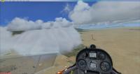
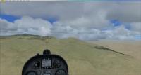
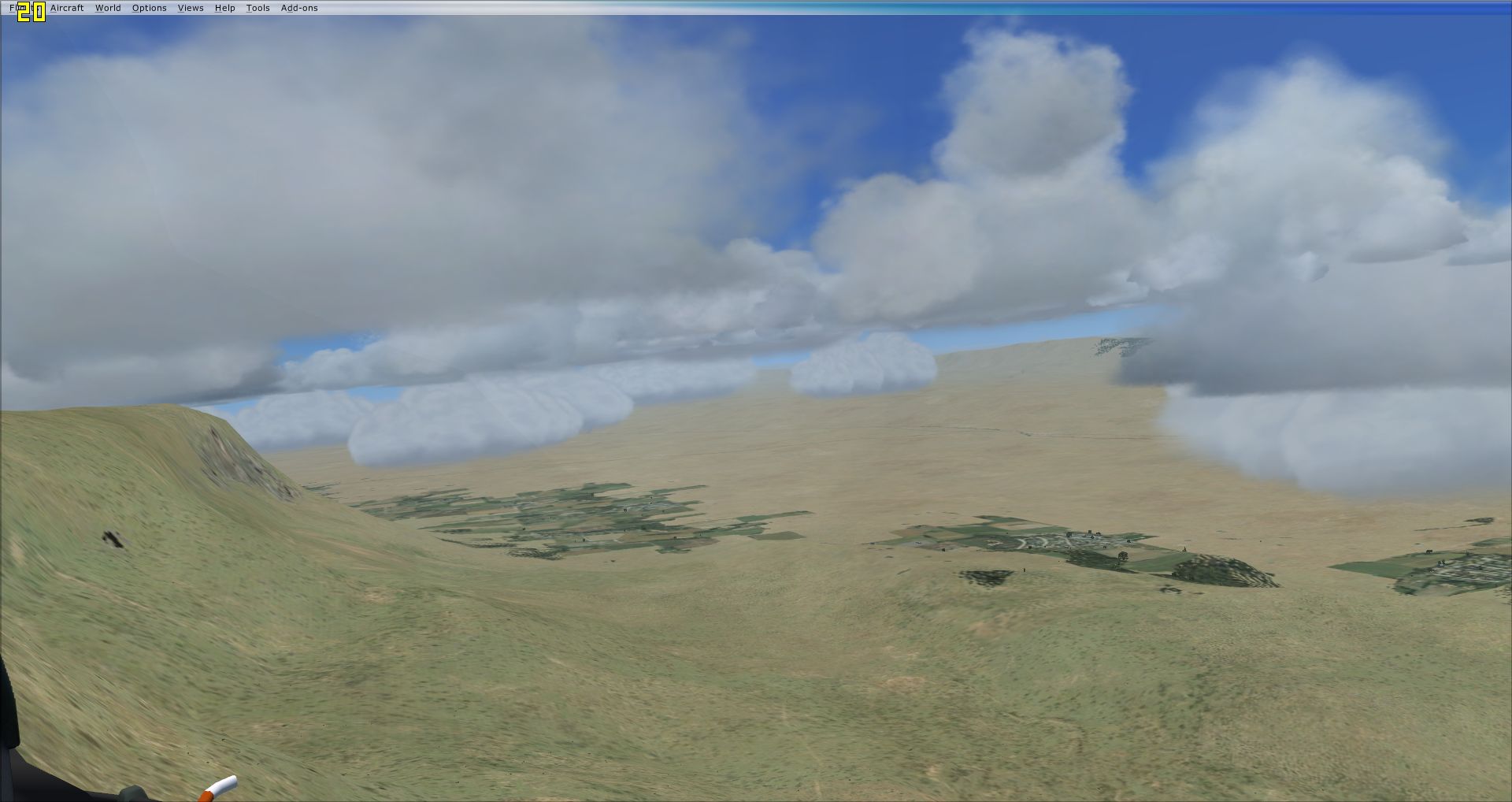
I recently flew a couple of tasks in desert areas, one around Heath Canyon, Texas, and other Minden, Nevada. I noticed that the CumulusX! clouds do not cast any shadows on the ground in those areas.
-
I've now flown the same aircraft (LS8-18) on two tasks, one using Max's CAISet instruments, and one using Ian's updated panel. On the most recent flight yesterday, everything Ian made for the updated panel worked perfectly as advertised. The only problems I encountered were task related issues with the FSX GPS.
The first issue is that it does not treat the waypoints as a circle when determining the arrival event, but rather assumes arrival when the flight path crosses the bisector of the angle between legs. Unfortunately, on this task, my "Smart" towplane happened to take me across that bisector. Consquently, the GPS began navigating to the next waypoint while I was still on tow. This brings me to the second issue, which is that there is no mechanism in the FSX GPS to undo or change this state.
Now I realize, if I'd had a little more presence of mind, I could have simply flown through the start waypoint, (using the moving map display) and headed out on task, knowing that all this could be sorted out at the IGC level. But, I'm thinking, we have some unused buttons on this instrument. Would it be possible to put those buttons into service to make this GPS a little more user-friendly for soaring tasks? Like, for example, backing up to the previous waypoint, or restarting the task?
Max's CAISet GPS-NAV handles this sort of situation the way a soaring pilot expects. The CAISet, modeled after the RL Cambridge soaring instrument, takes its cues from the pilot to determine when the task is started, and when to navigate to the next waypoint. Arrival at a waypoint is determined solely by proximity to the waypoint, i.e. the flight path passing inside a circle of a certain diameter around the waypoint.
Granted, the CAISet is a little more trouble to set up, requiring the creation of the task .dat file, but as it stands, the added features and behaviour described above more than makes up for the extra effort. And now it appears that Max may be revisiting the CAISet, and who can say where that might lead?
-
Panel best feature is the shadow beneath the 302 needle...

-
I have flown the LS8-18 before, but the one with Max's CAISet gauges. I just tried your update today, and everything worked beautifully. I preferred the vario switched to STF mode. The moving map I left with North up, even though I feel that having the aircraft icon pointing up is more intuitive. Both ways have their positives.
The only issues I encountered had to do with the behaviour of the FSX GPS when flying a soaring task, nothing to do with any of your work.
-
Masterfully done, Ian! A new standard in FSX soaring instrumentation and documentation.
(and I haven't even flown it yet)
-
An edition of HD video captures from a multiplyer memorial flight in honour of a friend and flightmate of ours, JJD, who died 30 December, 2010. My brother and I, and another friend, had been fllying regularly in Condor with JJD since October 2008. We're going to miss him a lot.
The task start was the Flying X Ranch, northwest of Canyonlands National Wildlife Refuge, near Austin, Texas, and turnpoints were JJD's house and his church. I'm not religious, but there was a CumulusX! thermal exactly over both turnpoints! Finish was an easy final glide from cloudbase back to the Flying X.
An unknown pilot who joined the multiplayer session, Stoastairer, flying the DG-808S, joined us on the last leg of the flight.
-
...Is this the default Maule or something else?
...
Thanks for input, Peter. Yes, it is the default Maule, invoked by CTRL+SHIFT+Y.
If it happens next time, we will try explore some options in the Traffic Browser.
-
Sorry, I could not get in on this, due to not having the DiscusX, but sounded interesting. How has it gone? Any submissions yet?
(screenshots, or it didn't happen!)

-
This has now happened twice to us in two different multiplayer tasks. What happens is that for a subsequent player that spawns on the runway, could be second or third player, the towplane does not start engine and take off, but just sits there on the runway. The player can end flight and respawn, this time getting an airspawn, however the towplane ends up sitting there on the runway the entire flight, even after the player who called it up has left the mutiplayer session.
Since we are all spawning on the runway, I can't rule out some kind of collision happening, undetected by us, which somehow damages the towplane, however in the second occurence, I'm certain the player was alone on the runway. I'm otherwise at a loss to explain or solve this.
Has enyone else encountered this issue?
-
I finally got a chance to fly this bird on a task last night. In Condor, I always fly the ASW28 for Standard Class task, so this was a way to compare apples to apples, and it turned out to be as docile and easy to fly. The only issue I noticed was difficulty getting it to slow down when circling, requiring almost full up elevator at times. Need to fly it some more to rule out pilot error.
The moving map is certainly an excellent tool for orienting yourself to the task. In the Condor PDA, north is always fixed to the top of the display, and it took a few minutes to get used to the aircraft icon being fixed, but once acquired, having the icon fixed is much more intuitive when maneouvering.
Of course, the B21 vario is your "one stop shopping" for soaring info, MC, netto, arrival height, averager, all clear and easy to read. The arrival height behaves as I expect when flying through lift...i.e. it increases.
Ian's TE vario, also good to have. Both this instrument and the ASI were indicating knots, which was not unexpected since this is, after all, the UKVGA ASW28! This is the same case as these instruments in DG-808S, where they also are only calibrated in knots, however, the B21 vario and the altimeter pick up my metric settings in FSX, so I'm left with an odd mixture of metric and imperial. I'm not familiar enough with FSX to know how this is supposed to work. I gather that some instruments can switch, and some cannot?
I had trouble getting full range of elevator trim with my rotary, and had to always apply some forward stick pressure for anything over 80 knots. It was possible to get a little more by clicking the mouse area on the panel, but it seemed only about 1 in 10 clicks were registering. This may be simply a conflict between having trim on an axis, and the click to trim function of this gauge. Also, this may be realistic, I don't really know. In the SOAR DG-808S and the LS-8-18, I've been able to get more forward trim out of the rotary. Same thing for pitch up trim, which may have been a factor in my difficulty getting it to circle slower.
The GPS, Ian, is this the same FSX GPS as in the DG-808s, or have you tweaked it any?
Video from this flight to come soon.
-
Running everything and Debut (freeware screen capture), running AMDFusion and setting affinities just right:
1280x720 - - - - > about 17 FPS but dipping to12-13 at times
I don't know how this compares to your 1024x576 frame rates, but if you can capture 1280x720 at 17FPS and upload that to YT, I think the image quality would be quite noticably better. Worth a shot, I'd say.
-
- the tanks can be (partly) filled only when the plane is on the ground...
Sorry, this is not directly addressing your problem, but re: the above...
How will that affect missions/flights which are started airborne? From the above, it seems an airborne flight would start with no ballast loaded, with no way to load ballast except to make a landing.
-
Just out of curiosity, then, what would you get if you ran FSX in a 1280x720 window?
-
...To do videos I set it up as 1024x576 (16:9) window resized to 1280x720 for YouTube specs...
What is the native resolution of your monitor?
I assume you're using 1024x576 to get better frame rates.
-
Yeah, the first time I tried the CAISet gauges, I was chasing the buttons around the monitor because of the TrackIR, but after a while it got easier. Worst case, I can F9 to disable the TIR to push buttons. I downloaded the popup ones, but don't know if I will use them.
-
Another edition of HD video caps from a multiplayer session on 04 January, 2011. This one was a 149km thermal task around Sarnia, Ontario (CYZR), which is where my friend Kitkat lives. (kind of a guided tour for me) First time with Max's CAISet gauges in the LS-8-18. Neither of us finished, however, and landed out near the last turnpoint, me right in downtown Sarnia.
I'm still getting the hang of the various views we have in FSX, but it's a little tricky to use some of them while flying.
Got to watch out for that stupid mouse cursor, too. Dang!
-
WOW, you have some awesome frame rates...
Well, thanks, guys. FPS limiter is only set at 20, Scott, which is kind of minimal IMO. What are you getting for frame rates?
-
I haven't really explored much of the weather options in FSX. For setting these tasks, I'm trying to avoid the unexpected, so I've been following the advice I have usually found associated with CumulusX!, which is to first select "Clear skies (clears all weather)" for the weather theme, then select User-defined weather...Customize...and set the single cloud layer where I want them to be. So far it has always resulted in what I expect...except for this one occasion, which seems not repeatable.
Are there occasions where the above procedure can still result in this sort of unexpected weather results? Would it help to edit the CumulusX! configuration so that the thermal height range matches what I'm setting in FSX for cloud level?
Now, don't get me wrong...I like soaring weather to have a little variation from run to run. In Condor, I always check the "Randomize" box, so that even though the weather is set a certain way, if I fly the same task twice, I don't see the same thermals in the same locations. I realize CumulusX! does not have such a checkbox, and that's fine. But this anomaly was a little too....anomalous, if you know what I mean.
-
Just a collection of HD video captures during our multiplayer session on 28 December, 2010
A 130km task at St. Johann in the Austrian Alps, with my brother and a friend.
-
Hmm...I just tried it a couple more times...did not change a single thing, and now everything is fine. Clouds all where they should be.
-
Here's some cake icing on the LS8-18, coming soon...
Yum!
-
I had read of Hodge's low cloud problem here:
http://www.forum.aerosoft.com/index.php?showtopic=24556
I just made a short task out of Heath Canyon. I am careful when setting weather to only set a single layer of cu at the height I want, so this task weather has a single cu layer 2200-3200m. I'm using CumulusX! with the default configuration, which has thermals from 1500-3000m, but I'm assuming it will use the levels set in the FSX weather.
And it did, for the most part. At Heath Canyon and around it, both the FSX and the CumulusX! clouds are all at 2200m, where I want them, but to the south towards the TP at Terminal, I can see some CumulusX! clouds that are lower. So, I head there, and sure enough, there is a broad region around the turnpoint where all the CumulusX! clouds are down around 1400m. The FSX clouds are all up at 2200m. Looking south and west, clouds are all up where they should be at 2200m.
What could cause this cloud level anomaly? It doesn't seem to be the same reason in Hodge's thread.


LS8-18 B21
in General Discussion
Posted
Holy Smackorz! And after you said it was way down on the To Do list!
Thanks very much, Ian!