


rlink
-
Posts
33 -
Joined
-
Last visited
Content Type
Profiles
Forums
Downloads
Posts posted by rlink
-
-
You need the ballast indicator to know the FULL and EMPTY weights of the LS7. It is made easy for you to find out those weights by simply putting the ballast indicator into "weight" mode as you discovered. Start with the glider on the ground, note the FULL reading, open the ballast valves and see what the reading gets to when all the ballast is gone (i.e. EMPTY). These weights are in Kg.
Then you have two ways to fix up the gauge in the LS7, both involve editting files:
(1) Add the "b21_polar_v2" gauge from the ASH25 into the LS7 as in the ASH25 (see panel.cfg) - it has a size of 1x1 so you don't see it. Open "b21_polar_v2\b21_polar.xml" in Notepad and edit the following two lines with the correct EMPTY/FULL weights for the LS7:
626  (>L:B21_polar_weight_empty, kilograms)

                        	746  (>L:B21_polar_weight_full, kilograms)
or the hackyhacky option number 2, just hardcode the FULL/EMPTY Kg figures into the ballast indicator gauge: (2) In the "b21_ballast" gauge you've already installed in the LS7, use Notepad to edit the file "b21_ballast\ballast_indicator.xml". There's an element section that looks like the following:<Element id="ballast proportion"> <FloatPosition>6,2</FloatPosition> <Visibility>(L:B21_ballast_weight_visibility, number) 0 ==</Visibility> <GaugeText id="B21_mc"> <Size>30,20</Size> <FontFace>Quartz</FontFace> <FontColor>#ffffff</FontColor> <FontHeight>20</FontHeight> <Length>1</Length> <Transparent>True</Transparent> <VerticalAlign>CENTER</VerticalAlign> <HorizontalAlign>RIGHT</HorizontalAlign> <GaugeString>%( (A:TOTAL WEIGHT, kilograms) (L:B21_polar_weight_empty, kilograms) - (L:B21_polar_weight_full, kilograms) (L:B21_polar_weight_empty, kilograms) - 100 / / int )%!3.0f!</GaugeString> </GaugeText>(a) Replace "(L:B21_polar_weight_empty, kilograms)" with the EMPTY WEIGHT AS A NUMBER, e.g. 666. Note that it appears TWICE in the code. ( Replace "(L:B21_polar_weight_full, kilograms)" with the FULL WEIGHT AS A NUMBER, e.g. 777.
So you should end up with a ballast_proportion element something like:
Replace "(L:B21_polar_weight_full, kilograms)" with the FULL WEIGHT AS A NUMBER, e.g. 777.
So you should end up with a ballast_proportion element something like:
	<Element id="ballast proportion">

        	<FloatPosition>6,2</FloatPosition>

        	<Visibility>(L:B21_ballast_weight_visibility, number) 0 ==</Visibility>

        	<GaugeText id="B21_mc">

            	<Size>30,20</Size>

            	<FontFace>Quartz</FontFace>

            	<FontColor>#ffffff</FontColor>

            	<FontHeight>20</FontHeight>

            	<Length>1</Length>

            	<Transparent>True</Transparent>

            	<VerticalAlign>CENTER</VerticalAlign>

            	<HorizontalAlign>RIGHT</HorizontalAlign>

            	<GaugeString>%( (A:TOTAL WEIGHT, kilograms) 666 -

                            	777 666 - 100 /

                            	/ int )%!3.0f!</GaugeString>

        	</GaugeText>
OK?
B21 / Ian Forster-Lewis
Thanks Ian!! I will give that a try. I appreciate your help, and I love flying your ASH25. Take care.
Randy L.
-
Hi b21,
I did download and install Ian Forster-Lewis's Schleicher ASH25 with the b21 panel. What a sweet glider that is! The water ballast gauge works great in the ASH25 so I imported that gauge to Wolfgang Piper's Rollade-Schneider LS-7 panel. The gauge works if I click on the gauge to display the aircraft weight. But for some reason the gauge does not display the percent of water in the tanks like it does in the ASH25. It simply reads "0" when it is in the LS-7 panel. Is there a way to configure this gauge so that it displays full ballast tanks "100%" at the beginning of the flight? As I said, it does work correctly in the LS-7 panel as long as it is displaying the aircraft weight, but I would love to have this gauge also display the percent full indication of the ballast tanks too, just like in the ASH25. Thank you for your help.
Randy L.
-
Hi Rob,
I checked out your link, and it is not quite what I had in mind. I was hoping to find something like the Max Roodvelt ballast gauge that comes with his FS9 Grob CS, but that would work in FSX. Thank you for your reply though. Take care.
Randy L.
-
Does anyone have a water ballast gauge that will work with FSX? I am looking for a gauge that will indicate the status of the ballast tanks, like a fuel tank gauge in a regular airplane. I have tried using Max Roodvelt's ballast gauge for FS9 that comes with the FS9 version of his Astir CS, but it does not seem to work. I cannot get this gauge to register full tanks, nor can I get it to fill the tanks as it does in FS9. I am hoping that someone knows of a ballast tank gauge that will work with Wolfgang Piper's LS-7 W in FSX. Thanks in advance.
Randy L.
-
I have a list of polars in my files, and I'll have a look tonight at what is there. I think the best thing now might be to
use Max's polar test gauge set, from his website:
Find it under the "Gauges" section. With that you can make a test fight and generate a polar on-the-fly. I haven't used it myself, but that's the way it's supposed to work.
Thanks Bulau, I will give that a try. Take care...
Randy L.
-
Does anyone have an LNAV_polar.dat file for Wolfgang Piper's Rolladen Schneider LS-7 that I can use with the Caiset LNAV gauge? I am currently using the .dat file that came with the gauge, but that is for an ASW20. I really love the LS-7 and that is what I have been flying mostly. I would love to get the correct LNAN_polar.dat file for this aircraft though. Any help would be appreciated. Thanks...
Randy L.
--Remember: Any landing that you can walk away from
is a landing that you can be fined, sued, or
prosecuted for.
-
Hi Peter,
I removed the joystick button assignment and used the Shft+Ctrl+Y command to request the tow-plane, and now it works as advertised. I am able to command the tow-plane to fly both left hand and right hand patterns now. Thank you so much for your help.
I would like to make a suggestion concerning the Smart Tow-plane for a future version of CumulusX. There are times when I would like the tow-plane to simply fly a continuous left hand or right hand pattern around the airport without it leaving the vicinity of the airport to look for lift. The problem that I have with the tow-plane making just one right turn (or left turn) and then going off to look for lift is that it often leaves me miles from the airport at a very low altitude. If I break the rope then I don't have enough altitude to make it back to the runway. I think it would be a good idea to not have the tow-plane leave the traffic pattern to look for lift until it has reached at least 1000 feet AGL. That way if we break the rope on tow then we have enough altitude to make it back to the runway.
I would like to suggest that in a future version of CumulusX that in the Configure Tow-plane menu that you keep the current choices that you have, but then add two more choices to the Configure Tow-plane menu. They would say something like "Left hand patterns around the airport to altitude" and "Right hand patterns around the airport to altitude". If one of these items is selected, then the tow-plane would simply fly a continuous left or Right hand pattern around the airport (of course there will be wind drift) until the glider pilot releases the tow rope.
Again, thanks for your help, and thank you for CumulusX. It is a terrific program! Take care...
Randy L.
-
Hi Randy,
dou you have mapped the "Request Towplane" command to a joystick button?
regards,
Peter
Hi Peter,
Yes, I have the "Request Towplane" command mapped to one of the buttons of my joystick.
Randy L.
-
I'm using the FS9 Caiset GPS and LNav gauges in most of the FSX gliders that I have installed. I have created a "GPSNav.dat" file for the area that I like to fly in. Everything works fine except that even though I have entered the airports field elevation in feet MSL, the Caiset GPS displays the elevation in meters. Is there any way to get the Caiset GPS to display an airports field elevation in feet instead of meters? The format that I am using to enter data into the GPSNav.dat file is this:
0001,43:33:52N,116:13:22W,2868F,A ,Boise ,Twr 118.100
Any help would be greatly appreciated. Thanks...
Randy L.
-
I just installed CumulusX in FSX and purchased a personal license for it. I love this program! I do have one problem with the Smart Towplane though. While I can change the towplane to any aircraft that I have installed in FSX using CumulusX, I cannot seem to make the towplane fly right-hand tow patterns. All that it does is fly left-hand patterns, no matter whether I select the right-hand pattern or not. This is towing out of airfields that have no high terrain on either side of the airport. The Smart Towplane is suppsed to fly a pattern, then fly to the nearest visible lift area, but all that it does is fly the left hand pattern without seeking out any lift. Also, after release, the towplane simply climbs and flys away, instead of returning to the field like it is supposed to. Before CumulusX I had a little add-on program called Aerotow installed. I removed Aerotow before installing CumulusX. The Smart Tow feature of CumulusX is acting as though it is controlling the selection of the towplane feature, but it is not controlling the direction of the tow plane. Any help would be greatly appreciated.
Randy L.
-
I understand the TE compensation and the Netto compensation in the Winter vario for the SOAR DG808S, and I even understand the MacCready altitude computation (altitude at arrival at waypoint) but I am not sure if I am clear on the MacCready Factor (the numbers 0 - 9 on the Cambridge vario). What are these factors - for instance, what do the indvidual factor values represent? And whan would you use these factors??
Just curious...
Randy L.
-
Where can I get more information on PlayClaw, and Roxio's Video Wave? I would like to try making a video myself.
Don
Hi Don,
PlayClaw is a commercial product that you can find at:
http://www.playclaw.com/en/index.php
The publisher offered it for free last week, but only for 24 hours (as a promotion) and I was lucky enough to find out about it and download it while it was free. I'm not sure how much it's going for now. PlayClaw is a lot like FRAPS, but doesn't impact framerates while it is running as much as FRAPS does. Plus PlayClaw is very simple to use (it would have to be for me to use it).
VideoWave came with Roxio's EZ CD Creator v9.0.
It's one of the utilities that comes with EZ CD Creator. I bought version 9 about a year and a half ago for ~$80, I'm not sure what version they are currently putting out.
I'm glad you liked the video, I had a lot of fun producing it. Thanks...
Randy L.
-
I don't know if this is appropriate here or not, so if it isn't then please let me know. I have created a soaring video using FSX, PlayClaw, and Roxio's VideoWave that I thought I would share. It can be found at:
This is a short soaring flight out of Bad Ragaz airfield, Switzerland in an LAK Genesis 2 sailplane using Microsoft Flight Simulator X. I also use a small program called "Aerotow" to select the towplane of my choice, and to get the tow plane to fly the pattern that I want. The Genesis 2 sailplane is a standard-class glider with ballast, and is one of the best freeware gliders that I have found for FSX so far.
This is the very first video that I have produced. Any comments would be welcome. Thanks...
Randy L.
-
It looks like Max took his site down. He said he was going to. It looks like another chapter is closed in virtual soaring history. I don't have a current e-mail addy for him.
Don
And that is a shame too. He really did have superior aircraft and tools. Thanks Don.
Randy L.
-
Just curious, is Max Roodvelt's FSZwever website no more? I can't seem to find it.
Randy L.
"I reject your reality and substitute my own!"
Adam Savage
-
I have Flight1's Ultimate Terrain USA X installed in FSX, and I must say that it really does a great job of enhancing the VFR scenery. Roads, highways, coastlines, landclass, rivers & lakes, etc look much more realistic now. However, after installing the FSX Acceleration pack, I was in for a BIG surprise. All roads, highways, and interstates were gone. All water features, including oceans, were gone! You can imagine how happy I was with this. Fortunately Flight1 has a small patch that fixes a few small scenery files, and a procedure for restoring all of the landclass and water features. After running the patch, and running the UTX Setup program again, all is as it was. I would recommend Ultimate Terrain USA X to anyone who wants really nice VFR scenery.
I thought I would post a few images of what the world would loook like with no water or oceans. I took these screenies before I leaned how to restore the textures.
Imagine several millennia in the future. Global warming has caused all of the great oceans of the Earth to either dry up, or shrink to a fraction of their previous glory. Sadly, mankind has died out, and now all that is left are the ancient ruins of a once mighty empire. It is a bright, sunny day above the ancient city of San Fransisco, once a jewel sitting on the edge of a mighty bay. You take a flight in an ancient primitive flying machine, the last of your kind...
http://i25.photobucket.com/albums/c62/rlin...ter01_small.jpg
http://i25.photobucket.com/albums/c62/rlin...ter02_small.jpg
The rusting ancient hulks of mans mighty fighting machines litter the dry sea bottoms of the world....
http://i25.photobucket.com/albums/c62/rlin...ter03_small.jpg
And mankind's once proud memorials to long forgotten conflicts slowly crumble to dust...
http://i25.photobucket.com/albums/c62/rlin...ter04_small.jpg
As you leave the long abandoned shoreline for the final time, you head out over the globe-encompassing savannah; all that is left of the once great Pacific ocean...
http://i25.photobucket.com/albums/c62/rlin...ter05_small.jpg
(Insert Twilight Zone theme music here)
The procedure for fixing UTX after the FSX Acceleration Pack install is here:
http://www.simforums.com/forums/forum_posts.asp?TID=23111
Randy L.
--
"Well, my days of not taking you seriously
are certainly coming to a middle."
-Malcom Reynolds - Captain of 'Serenity'
-
I was just wondering. Does setting all of the weather parameters manually in FSX have any effect on thermal generation? I mean, is there a specific group of settings for wind, clouds, temperature, barometric pressure, etc that would give you more thermal activity than just using the default "Fair Weather" theme? I have fiddled around with different weather parameters manually, but so far I don't see any better thermal activity than if I use the default "Fair Weather" theme.
The reason I ask is because I have a favorite airport that I like to tow out of. But when I use the "Fair Weather" theme, the thermals in this area are very few, and VERY far between. And so far no matter how I tweak the weather manually, it doesn't seem to get much better. Does anyone have a set of weather parameters that works well for thermal generation? Or are we just stuck with whatever thermal activity that the program wants to give us regardless of how we manually set the weather?
Randy L.
"A good landing is one in which
you can use the aircraft afterwards."
-
At least the vario of the FSX-DG808 is cheating you. If you take a stop watch and look at the real altitude by Shift-Z you will find out that the sink at 60 kn IAS/63 kn TAS is at 1.6 kn (in 3000 ft, flaps +4, 15°C, QNH 1013) which results into L/D of only 41 while the "DG808-vario" reads -0.4 kn which is according to the "Training-Center" the speed of the thermal updraft shown by a "comepnsated vario" (BTW, the first I looked into it for the DG).
As this is the 18m version, the real DG808S has approximately 1:50 at 60kn/110 km/h IAS and 1220 lb/525 kg. Minimum sink is 0.47 m/s at 41 kn/75 km/h _and_ 790 lbs/340kg.
best regards,
Peter
Hi Peter,
I noticed at the DG web site that they had performance data listed for 2 different versions of the 18-meter DG808S. One version had winglets, the other didn't. I noticed that the 18-meter version with the winglets had a slightly better L/D than the one without the winglets. I wonder if Microsoft modeled the winglet version for FSX, but used the performance data from the version without the winglets? That sounds like something that Microsoft might do.
Randy L.
-
Yep, they work on my computer. Here is a demonstration of it. The most forward position is the -14 I would assume.
sf4JC
Hi sf4JC,
The flap settings in the FSX DG808 are printed next to the flap actauator handle on the side of the cockpit. The scale for the flap settings reads "L, 8, 5, 0, -10, -14". However, the simulator only allows you to move the flap lever in four positions. It looks to me like it moves to "L, 8, 0, -10, -14". I still think that one cannot move the flaps to all of the indicated flap settings, but it's no big deal. As long as I can move the flaps downward, and upward then I'm happy. Now I really am confused about something. Are negative flap settings ones where the flaps trailing edge are postioned above the wing chord line? I'm curious because in the pre takeoff checklist for the DG808 it says to place the flaps in the "takeoff position (+13 degrees)". A positive 13-degree flap position would be extended all the way down, wouldn't it? I have never heard of areo-towing a glider with the flaps extended all the way down. The only time that I have ever areo-towed a glider that had flaps (a Blanik L-13) the flaps were set at 0 during takeoff and all through the tow. But again, I have never flown a really high-performance glider like the DG808. I would think that the extra drag of the fully extended flaps wouldn't be a good thing on takeoff. But then again it would tend to pitch the nose of the glider down for better visibility of the tow plane.
By the way, I did find the performance data for the FSX DG808S... right where I should have looked to begin with - the kneeboard! It has both checklists and performance data. I created my own checklist and performance data sheet with MS Word using this data, as I have created original checklists for all of my FS9 and FSX aircraft that I fly the most. I like to have a printed checklist so that I don't have to have a window open while I am flying.
Although I have never flown a DG808, I have logged about 120 hours in various and assorted sailplanes. Most of my time has been in Schweizer aircraft. And I have my license for both single engine airplanes and gliders. I must say that flying MSFS is much cheaper. I appreciate your reply, and the link to the video. Take care...
Randy L.
-
I have been flying the DG808S glider a lot lately in FSX. But now I would like to fly it a little more intelligently. Does anyone know where I could find performance data (like a Pilot Operating Handbook) online for this aircraft? I did find a limited amount of performance data at the DG website, but I don't know if this data bears any relation to the aircraft in FSX. I would like like to find the reference speeds for the aircraft (Vso, Vs1, Vfe, Vne, etc) as well as best L/D speed, minimum sink speed, best speed-to-fly, etc for both the ballasted and non-ballasted aircraft and different flap positions.
Also, I notice in the FSX version of the DG808 that there are more flap settings above the flap actuator handle - even negative flap settings - than you can actually move the flaps to in FSX. Does anyone know if one can move the flaps to more settings? And if I set the flap actuator handle to the most forward position, is this 0 degrees flaps, or -14 degrees flaps? So far I have only been able to move the flaps to 4 positions and I would love to find out what all 4 of those positions actually relate to. I would love to use the negative flap settings, if they work in the FSX version of the aircraft.
Thanks for your help...
Randy L.
"When making an emergency off-field landing at night
turn on the landing light just before touchdown.
If you don't like what you see, then turn off the landing light."
-
By the way, have you given any thought to using Funky's cumulus cloud model for the natural thermal visualization?
Do you find it reliable or useful to use the default birds,
One more thing, have you tried this flight with real-world weather? sf4JC
Hi sf4J,
I have seen the cumulus cloud visualization on flightsim.com, but I haven't installed it yet. I do enjoy soaring with the hawks, but unfortunately it has been my experience that not all areas, or even all thermals have hawks in them. Do all of the thermals in an area have a cumulus cloud above them? I would like to use something that makes it easier to spot the thermals. It's too bad that someone can't make a hack that would allow one to use BOTH hawks OR cumulus clouds at the same time.
I have used real world weather several times in the Mont St Michel soaring flight. It makes it much more challenging. When I originally set up and saved the flight, it just so happened that the tow plane flies through an 800 fpm thermal with hawks in it while we are almost at release altitude. All I have to do when using the default flight is to release in this thermal and I can pretty much rely on a thermal to 8000 ft MSL. This gives me plenty of altitude to make the glide to the island of Jersey, with enough left over to fly a normal landing pattern at Jersey Intl. airport. The airport is on the far side of the island. The last time I flew with real world weather turned on though, I left the coast of France at 6000 ft MSL, and just barely had the altitude to make it to the island. I had to land in an open field near the southwestern coast of the island, as I didn't have enough altitude to make the airport. But so far I have never had to ditch in the ocean. Sometimes though, when I call Jersey Tower they clear me to land on runway 9. Then while I am on my downwind leg of the landing pattern the tower clears someone else for takeoff or landing, and orders me to go around! Grrrrrr....
Thanks for the reply...
Randy L.
"Remember: and landing that you can walk away from
is a landing that you can be fined, sued, or prosecuted for."
-
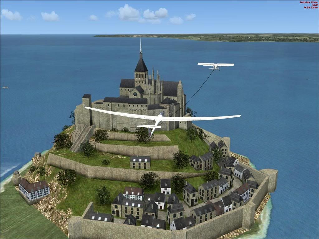
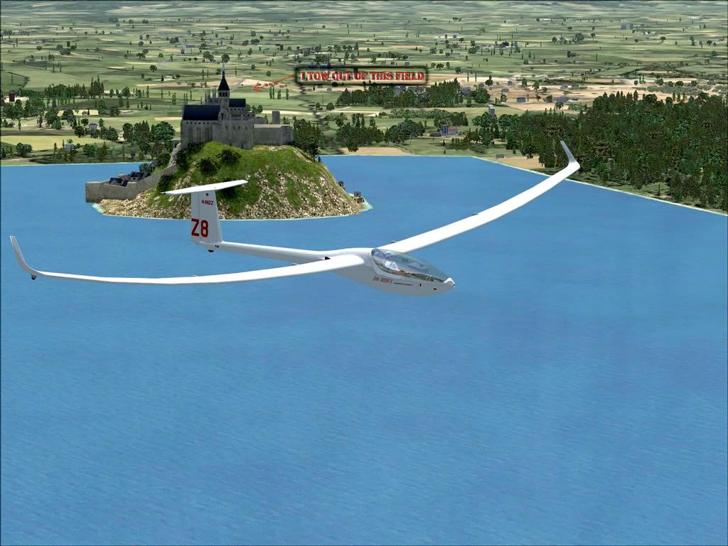
I have created a quite enjoyable flight in FSX that I thought that I would share. I start the flight in the DG-808S sailplane, on the ground in a farm field about one mile inland from Mont St Michel, France.
http://i25.photobucket.com/albums/c62/rlin...chelTakeoff.jpg
Mont St. Michel is this beautiful 13-century abbey built on a small island off the coast of France. My objective is to fly cross-country (or cross-ocean!) to the island of Jersey - one of the Channel Islands - and land at Jersey Intl (EGJJ) which is a flight of about 45 miles. I enter the ICAO code for Jersey Intl into the Garmin GPS, so that it will show up in the DG-808's own flight computer. There is no airport at the takeoff point, so I am using just an open field next to the main road; it was easy to get my gliders trailer into there. I have aligned the direction that the sailplane is pointed in the field so that when the tow plane starts its tow, we will fly right over the abbey. After calling the tow plane, we take off and fly right over Mont St Michel, which is an incredible sight to start with.
http://i25.photobucket.com/albums/c62/rlin...tStMichel06.jpg
After towing to ~2000 MSL (I'm over the ocean by then) I release the cable and start looking for hawks. There are usually some hawks soaring a few miles northwest of Mont St. Michel. I fly towards the hawks until I am in the same thermal, and I start climbing at about 800 FPM in the thermal.
http://i25.photobucket.com/albums/c62/rlin...ithHawk02_B.jpg
There is usually not very many thermals out over the ocean between the coast of France and Jersey, so I make sure that I climb high enough before I get too far away from the French coast to make it all the way to Jersey in one long glide. An altitude of about 8,500 ft MSL usually works well. Once I attain the altitude that I need, I start heading for Jersey. The heading to fly is ~320-degrees magnetic, and I am watching the GPS on the DG-808's flight computer to make sure that I am on course. Then I trim the sailplane for the best speed-to-fly and settle in for about a 40 minute flight.
http://i25.photobucket.com/albums/c62/rlin...tMichel04_B.jpg
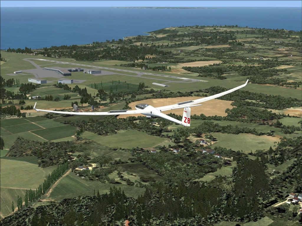
About 10 miles from Jersey, I call Jersey Tower, and let them know of my landing intention.
http://i25.photobucket.com/albums/c62/rlin...JerseyIsl_B.jpg
http://i25.photobucket.com/albums/c62/rlin...JApproach_B.jpg
They usually want to set me up for right traffic for runway 09, and give me my landing clearance. If I am really, really lucky they won't clear any other aircraft for takeoff or landing while I am in the pattern, and then order me to go around. On my downwind leg I dump the ballast and am working the spoilers, killing any excess altitude that I might have. Depending on the flight that I just had, there may be NO excess altitude. As a matter of fact, I tried this flight once and just barely made it to an empty field near the beach on the very edge of Jersey island. Fortunately I have never had to ditch at sea (so far). Finally I turn onto the right base leg over the coast, and onto final approach for runway 09. The landing is uneventful (the way I like them) and fortunately I have enough speed and momentum to coast off the runway and onto the taxiway.
http://i25.photobucket.com/albums/c62/rlin...eyLanding_B.jpg
Then I have to cheat a little and use Slew to park the aircraft. Finally, it's time for a brewski!
http://i25.photobucket.com/albums/c62/rlin...JerseyEnd_B.jpg
I hope you enjoyed the flight as much as I did...
Randy L.
--
Remember: Any landing that you can walk away from,
is a landing that you can be fined, sued, or prosecuted for.
Water Ballast Gauge for FSX
in General Discussion
Posted
Hi Ian,
I edited the XML file as you suggested, and the gauge works perfectly now. Both weight and percent are now displayed. I appreciate your suggestion and your help. Thanks again.
Randy L.