


grrr05
-
Posts
1 -
Joined
Content Type
Profiles
Forums
Downloads
Everything posted by grrr05
-
Version 1.0.0
628 downloads
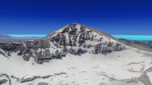
Welcome to Spain. This is a set of new photoscenery that covers the entire country, mainland and islands. Its main features are: -100% free imagery and elevation data, from official sources. -High definition mesh, generated from scratch with Meshtool 3 and official MDT25 elevation data (25meter resolution), -High resolution imagery. Zoom level 17 on mainland and 18 on islands. Unlike Google's imagery that comes in compressed jpeg, our textures come from uncompressed GeoTiff sources, with only one stage of compression (DXT1), keeping a higher level of detail and sharpness. -16bit unsigned DEMs with equalized histogram, with variable vertical resolution between a few millimetres and 6 centimetres. Main airports and several airfields have been handworked to keep slopes as real as possible. -No visible watermarks on imagery. -"Live" project. If needed, in the future we'll update the necessary files (usually only dsf,) if the underlying terrain of an airport or airfield needs to be fixed, or other possible errors such as gaps in the mesh or distorted textures. And who knows, perhaps we'll fix the chromatic differences between regions in the long term... -Andras Fabian's (AlpilotX) autogen vectorial data extracted from HDMesh v3 (and UHD where available) with his kindly permission. And what happens with France and Portugal? -Sadly there's no free source of imagery (and elevation data) of both countries, so beyond the Spanish border there's only default terrain. There's no "continuity" with other photosceneries such SimHeaven or Zonephoto, due to the architecture of X-Plane Sceneries. If you want to keep that "continuity" just don't install the border tiles, but expect differences in texture definition and mesh gaps within the line between tiles. Andorra and Gibraltar are fully covered. About inland water bodies; no X-Plane water has been used. Instead, we used transparent polygons extracted from CORINE, with the same physical properties as water. So you still can land on them with a seaplane. You won't see an "animated" water with reflections, but you will see the almost-real shape of dams and waterfalls. The official elevation data renders the inland water bodies flat, and the rivers should keep their slopes. By clicking the Download button you will be redirected to an interactive map in our site with the download links. Don't worry, you'll find a Google Translate box in the right frame Every tile or island group have 2 or 3 links: DESCARGAR (Main download - High availability, hosted in our dedicated server) MIRROR (Only some tiles - Medium availability, hosted in Dropbox Pro, limited to 200gb/day on total bandwitdh, if exceeded the links will be down for three days, we don't have control over this) TORRENT (Low availability, the seeding is done by volunteers, the newest tiles are the slowest ones) Inside every file you'll find a README.txt with installation instructions, credits and source notes. Just unzip the content of each file into Custom Scenery and define them with lowest priority in your "scenery_packs.ini" or above any other mesh-based scenery (like HDMesh or SimHeaven's photosceneries) The site of the project: spainuhd.blogspot.com (again, there's a Google Translate box in the right frame) More info (spanish) http://www.x-plane.e...p?topic=10061.0 http://www.x-plane.e...p?topic=10077.0 Orthographic photo and other data sources: Mainland and Gibraltar orthophotos: PNOA, Instituto Geográfico Nacional de España . Canary Islands orthophotos: Ortoexpress, GRAFCAN . Balearic Islands orthophotos: IDEIB, Servei d'Informació Territorial de les Illes Balears . Andorra orthophotos: Govern d'Andorra . Spain elevation data - MDT25: Instituto Geográfico Nacional de España. Andorra elevation data - MDT15: Govern d'Andorra . Coast lines: OpenStreetMaps . Inland water bodies: Corine, IGN + European Environment Agency . Autogen vectorial data: Mesh HDV3 / UHD, Andras Fabian . A few notes: - The overall size is about 330GB. - 4GB VRAM and 8GB RAM recommended. Can work on systems with lower specs, but you'll need to sacrify some rendering options, - Some small airports and airfields need the terrain to be fixed, We are working on it, eventually we'll publish small updates (usually only the DSF file) - There are BIG chromatic differences between autonomous communities. We don't have any plans for now, this requires a lot of work and our free time is limited. - No bathymetry. The current version of Meshtool don't support it. If a new version is released we'll rework the coastal tiles. - SpainUHD comes from free sources, and it's made mainly with free and opensource tools, but hosting the files costs us money due its size. If you appreciate our efforts please consider a small donation (not mandatory ) Enjoy it Albert Ràfols José Ángel Estevez Evaristo González Jordi Duran Juanjo Manzano Pau Gómez
