


krivadesign
-
Posts
111 -
Joined
-
Last visited
-
Days Won
2
Content Type
Profiles
Forums
Downloads
Posts posted by krivadesign
-
-
If you need some shots from the inside of the tower, give me a shout, I'll make sure you get what you need. (or better shots from any of the buildings on the skeyes site, for that matter.)
-
 1
1
-
-
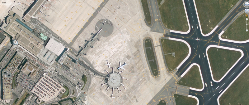
The airport will get quite a few major overhauls in terms of aprons in the next year or two. Are you guys aware of this, and do you plan to include these updates?
It will be quite an impactful change, with works continuning throughout for the next two years.
-
A side question, which may have already been asked, but I may have missed it: Will the relevant VFR reporting points within BRU CTR also be modelled, or will it 'just' be the very close vicinity of the aerodrome?
-
I had a look earlier today, and the markings are still pretty much exactly those you can see on Google Maps. (Only leading in from one side, and overshooting the gate on pretty much all of them.)
-
 1
1
-
-
I do, and I'll try to have a look tomorrow, if I remember it, and have time to do so.
-
I had some time to check during my breaks today, and the markings I was able to check, seem to conform to the AIP (or rather the AIP to the markings), as it should, of course.
-
-
2 hours ago, phlpeo said:
Google earth currently shows something different. And those don't show jetways on the round terminal. And the one above has been demolished.
Sure, but that's not what Schnuupi was on about, hence my reference to the date in the upper left corner. He said that there have never been jetways at the Satellite building. There were jetways, I've used them in the past.
The previous developer of the Brussels Airport scenery probably had to pick a date in time for which they had all info, data etc. they required. As will this developer have to do. For this scenery, that date will probably not be the same date as the release date, since it would be impossible to have the entire airport up to date, all the time.
For example, if they launch this scenery early 2017, it may "only" be up to date with how the airport actually stood at some point in Q2-Q3 2016.
For all we know, even though the previous version of this scenery was released in 2007, they may only have been able to get all the data they needed for some date in 2005.
-
1
-
-
Soooo... You're saying that this sattelite image is incorrect, and in some way photoshopped by me?
Take a look at the date in the upper left corner.
-
1
-
-
While I certainly understand work is still very much in progress, I'd like to remind you guys about a fairly recent addition to EBBR, the "football pitch" between 25R and 19, put in place to avoid pilots lining up on the wrong runway.
It can be seen quite clearly here: https://goo.gl/maps/wfNiueRySP42
Although, in real life, it looks a lot greener than it does in the photos on Google Maps.
-
1
-
-
I'm sorry, but there's really no use to those kind of posts.
It's not like the developer would have forgotten they were working on a new version of BRU, only to wake up and start development again because somebody asked about it on some forum.
Give them time, they'll provide updates when they feel it is opportune to do so.
-
4
-
-
It may be a bit pedantic, but it's actually runway 01 these days, not 02.
And in a few years, 25R might/will actually become RWY 24, dependant on variation changes.
-
As far as I can tell, v2 will be "from the ground up", and not an evolution on the previously released EBBR.
As such, I don't see why it would be necessary for Aerosoft to provide a discount. It's not like they kept the project for the new version a secret.
They may provide previous customers with a discount, but I seriously doubt it.
To the developers: as has been said before, a construction area is present on the northern side of the apron these days, where they demolished Hangar 117, and are building a new sorting center (with airside access) for DHL. Would a map indicating where the new sorting center is being built, be of any use to you? I don't think I'll be able to provide a lot of detail, but it might be better than nothing.
-
I'll see if I can get around to it. Might take a while though, since I have some other obligations these days.
-
I kind of missed Mathijs's post. However, driving by those buildings pretty much daily, I can tell you that they look very lifelike.
")
-
1
-
-
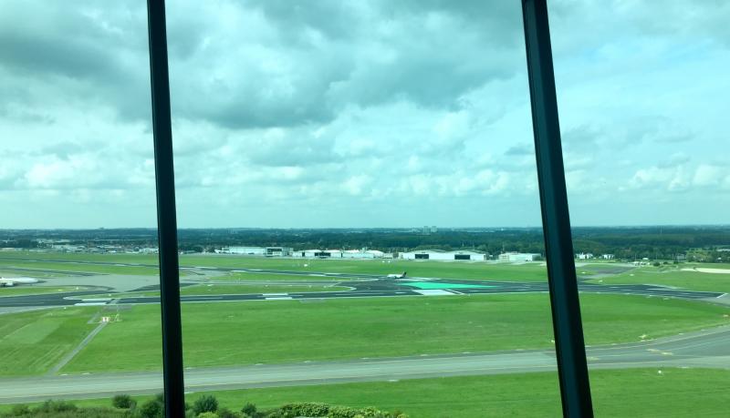
I'm not sure whether you guys know this or not, since it seems to be a relatively new development at the airport:
At the intersection between RWY 25R and 19, at holding point B1, the surface of the intersection has been painted green. It should be visible (and a lot more obvious than my explanation was) on the included picture.
-
3
-
-
If there's any info you guys are still missing, send me a message. I'm very confident we'll be able to figure something out ;-)


Offshore Landmarks-: North Sea (released)
in Product Previews
Posted
For Belgium, the same info is available in the AIP, ENR5.4.
https://ops.skeyes.be/html/belgocontrol_static/eaip/eAIP_Main/html/index-en-GB.html