


Will C
-
Posts
63 -
Joined
-
Last visited
Content Type
Profiles
Forums
Downloads
Posts posted by Will C
-
-
I think the answer to this is "NO" and that's fine.
But for purely aesthetic reasons, I'd like to remove the asterisk from *CLB and *DES on the OFP. Is that possible? Just curious.
-
Hmmm, that would be 14 separate directs, one for each departure point from O'Hare... And I don't know how to get PFPX to choose the right one of the 14...
I think I'll just keep a copy of the chart handy and enter the waypoints manually. (grin) Seems like less work, right?
-
Interesting, that's helpful but it doesn't solve the mystery. Take a look at the first VATSIM chart, the one titled "KORD RNAV (GPS) Departure Routes/Fixes."
It shows a preferred route to the northeast of RAYNR BRTMN TAAYZ and so on.
In both the cases above, I was going to the northwest. So I would think PFPX would give me PMPKN NEATO DLLAN RONIC BAE (etc.)
But in any event, the route to TAAYZ going north doesn't really take me off course until PETTY, which is the first intersection to the east. That's the one that takes me out of my way. It would be appropriate for a northeast departure, but it's odd for a northwest departure.
For a trip to KSFO, I think PFPX should have picked the PMPKN-BAE segment on that chart, not not the RAYNR-PETTY-BAE segment.
Steven, thanks, I can find that window on PFPX but it seems to only show the preferred initial fixes?
-
When departing to the north or west from the westbound runways at KORD (for example, KORD-KSFO departing 27C, also KORD-VHHH departing 27C), PFPX likes to give me no SID and the following: RAYNR DCT BRTMN DCT TAAYZ DCT PETTY and then on course.
Is this snippet published somewhere? It would seem like a pre-determined route segment, since it shows up frequently, but it's not part of the only published departure (OHARE7, which is just vectors) as far as I can see. And the dogleg to PETTY (to the northeast) seems like a needless extension of the route, which is why I'm wondering about this. For example, the route to KSFO was:
RAYNR DCT BRTMN DCT TAAYZ DCT PETTY DCT BAE ... , so we were actually backtracking a bit. To VHHH it was:
RAYNR DCT BRTMN DCT TAAYZ DCT PETTY DCT GRB ... , which isn't a backtrack but isn't as direct as (for example) TAAYZ DCT GRB.
I could assume that it's a preferred route segment for the purposes of traffic flow, but is this published anywhere? And where would the data be stored within PFPX?
Just curious, thanks.
-
-
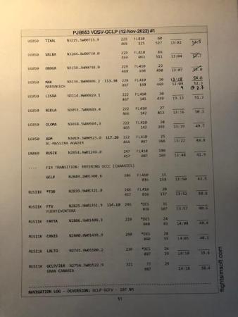
Hypothetically, the route is OERR-GCLP. The STAR is RUSIK1K which ends at LALTO.
The approach is going to be GCLP ILS Z Rwy 03L, which involves a 12 mile leg from LALTO to intercept the 10 DME arc from LPC to the final approach course.
My question has to do with fuel planning for the approach. The stretch from the origin (OERR) via RUSIK1K to LALTO is fine, but PFPX plans a direct leg from LALTO to the airport, whereas the approach takes a non-direct route because of the DME arc. This increases the fuel burn, especially if ATC ends up asking for the arc to be flown at a constant altitude.
Therefore, what is the typical and preferred way to account for extra fuel burn in the approach itself? Would you add this to contingency? Or to "Approach Time" on the Aircraft editor? Or somewhere else?
Thanks.
-
Thanks, that's helpful.
-
Thanks, Stephen. What is AIP, and how can I check it myself? Might save me some time in the future.
I appreciate your help.
-
I don't have a PDF of the whole OFP but here is a pic just after that stretch of the flight. On a new airway here, but as you can see, the direction is still west (roughly 220 degrees) and the altitude is still FL410. (I'm not sure how helpful one page of the OFP is, but at least you can check whether I'm hallucinating.)
Navigraph is the provider, the cycle is current.
-
Sorry if this is a basic question. I planned a flight that includes a long west-bound stretch though Algeria and Morocco on airway UA411. The aircraft is a B744.
PFPX planned an altitude of FL410 for that part, and I'm having a bit of trouble understanding why that altitude was chosen. A non-RVSM altitude should be either FL390 or FL430 for that part, while RVSM should be FL400, unless I'm mistaken, which may be the case.
I was flying at FL410, when (through RealTraffic) I noticed an actual real-world aircraft at my altitude heading eastbound on the same airway, also at FL410, which would be the appropriate altitude for eastbound traffic using RVSM, so I had a TCAS resolution advisory and had to climb out of its way.
My questions are these:
1. Any idea why PFPX planned my flight for FL410 going westbound? and...
2. Does PFPX "know" what parts of the globe are RVSM-capable and does it take that into account?
Thanks guys.
-
Just renewed my license today, no troubles... the PFPX + TOPCAT combo still works really well, I agree with Ray above.
Any potential customers need to be aware that there aren't any new versions, bug fixes(*), expansions, or updates planned, at least not that have been announced. So the suite is more or less frozen in time. But for what it is, it still works well and I use it for every flight.
*) They do seem to be fixing server errors, but not updating the PFPX or TOPCAT code itself. (At least not that I know about.)
-
I have about 1500 hours in the Twin Otter, but I would not be a good tester, because I literally never was in the cockpit when I wasn't wearing an excellent headset. It's a seriously loud plane! I have no idea what it sounds like without a headset.
-
My two cents are that I would add this in the Aircraft Editor, since MELs are specific to the aircraft. Enter it in the Aircraft Editor when the item is deferred or INOP, and then clear it on the Aircraft Editor when the item get fixed.

As Stephen says, not every OFP is configured to display the aircraft remarks, so you'll need to be using an OFP that does.
-
Well, it's not really what I'm trying to do in PFPX, rather what I'm trying to get the OFP template to display. The problem was that the displayed format was incorrect unless an alternate was supplied. However, using the fix above, the template now prints with the correct layout, regardless of whether an alternate is used or not.
-
 1
1
-
-
Hello Alicia,
I don't know any of the answers to your questions, but I wanted to wish your brother all the best, and say thank you for sharing his art!
Will
-
1
-
 1
1
-
-
-
Hello Stephen and all,
For the route between the redispatch airport and the redispatch alternate, we have the value <&RedispatchAltnGridMORA>.
Is there an equivalent for the stretch between the redispatch point and the redispatch airport?
I've tried a few permutations but nothing seems to work. If there is one, I obviously haven't stumbled upon it yet.
Thanks.
-
Okay, it's working now. The secret is to enclose the whole thing in <&RedispatchAlternate>.
It looks like this:
<&RedispatchAlternate_Begin>
... insert text header here ...
<&RedispatchAlternateNavLog_Begin>
<&RedispatchAlternateNavLog_End>
<&RedispatchAlternate_End>
-
Thanks for the speedy reply. This works if there is a redispatch alternate, but I'm having a problem if "Isolated" is selected and there is no redispatch alternate.
It seems this section is called and sent to the OFP, even if redispatch alternate is undefined. Is that my error?
In other words, whatever is contained within
<&RedispatchAlternateNavLog_Begin>
<&RedispatchAlternateNavLog_End>
...is still being sent to the OFP, even when <&RedispatchAltn> is blank.
-
Hi all,
Sorry if this has been asked before. I searched the forum and couldn't find anything.
I'm looking for a way to create a NavLog on the OFP from the redispatch destination airport to its alternate. I can find the distance, fuel burn, time, and ATC route from the redispatch destination to its alternate, but I can't find tags to delimit a NavLog section.
Obviously you can make a NavLog from the redispatch point to the redispatch destination with
<&RedispatchNavLog_Begin>
<&RedispatchNavLog_End>
so I was hoping for something analogous, like:
<&RedispatchAltnNavLog_Begin>
<&RedispatchAltnNavLog_End>
...but it doesn't seem to exist. Is making this NavLog a possibility, or just something that PFPX doesn't support?
Thanks, everyone.
-
Hello all,
Is there a way to exclude an entire country, or do you have to exclude each of the country's FIRs individually?
Thanks.
-
Sorry to hear about the lack of future development. As is, the program is still quite usable (and enjoyable). So I have the same question others have posted -- will data subscriptions still be available after the current ones expire?

Remove the asterisk from *CLB and *DES?
in Professional Flight Planner X (not for sale anymore)
Posted
That's what I thought, thanks.